
Faire un don
Équipez-vous pour votre prochaine aventure :
En tant que Partenaire Amazon, ce site perçoit une commission sur les achats éligibles sans surcoût pour vous.
Carte topographique Geismar
Cliquez sur la carte pour afficher l’altitude.
Faire un don
Équipez-vous pour votre prochaine aventure :
En tant que Partenaire Amazon, ce site perçoit une commission sur les achats éligibles sans surcoût pour vous.
Geismar
Geismar is an unincorporated community in Ascension Parish, Louisiana, United States and is at the heart of Louisiana's chemical corridor. The community is part of the Baton Rouge metropolitan statistical area. Geismar is south of Prairieville and west of Gonzales. The community has Three schools, Dutchtown Primary School, Dutchtown Middle School and Dutchtown High School, which are ranked among the top schools in the state of Louisiana. The Mississippi River flows to the southeast along the southwest side of the community. The area is vulnerable to hurricanes and tropical systems due to its low elevation and its proximity to the coast of southeast Louisiana.
Faire un don
Équipez-vous pour votre prochaine aventure :
En tant que Partenaire Amazon, ce site perçoit une commission sur les achats éligibles sans surcoût pour vous.
À propos de cette carte
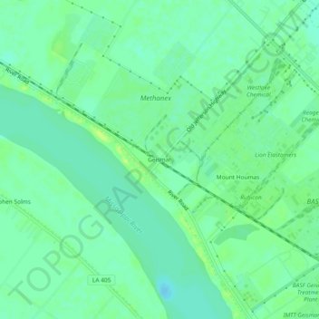
Nom : Carte topographique Geismar, altitude, relief.
Lieu : Geismar, Ascension Parish, Louisiana, United States (30.18436 -91.04260 30.22436 -91.00260)
Altitude moyenne : 7 m
Altitude minimum : -1 m
Altitude maximum : 17 m
Faire un don
Équipez-vous pour votre prochaine aventure :
En tant que Partenaire Amazon, ce site perçoit une commission sur les achats éligibles sans surcoût pour vous.
Autres cartes topographiques
Cliquez sur une carte pour visualiser sa topographie, son altitude et son relief.