
Faire un don
Équipez-vous pour votre prochaine aventure :
En tant que Partenaire Amazon, ce site perçoit une commission sur les achats éligibles sans surcoût pour vous.
Carte topographique Yarkand
Cliquez sur la carte pour afficher l’altitude.
Faire un don
Équipez-vous pour votre prochaine aventure :
En tant que Partenaire Amazon, ce site perçoit une commission sur les achats éligibles sans surcoût pour vous.
Yarkand
Yarkant County, also Shache County, also transliterated from Uyghur as Yakan County, is a county in the Xinjiang Uyghur Autonomous Region, China, located on the southern rim of the Taklamakan Desert in the Tarim Basin. It is one of 11 counties administered under Kashgar Prefecture. The county, usually referred to as Yarkand in English, was the seat of an ancient Buddhist kingdom on the southern branch of the Silk Road and the Yarkand Khanate. The county sits at an altitude of 1,189 metres (3,901 ft) and as of 2003 had a population of 373,492.
Faire un don
Équipez-vous pour votre prochaine aventure :
En tant que Partenaire Amazon, ce site perçoit une commission sur les achats éligibles sans surcoût pour vous.
À propos de cette carte
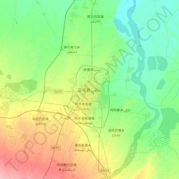
Nom : Carte topographique Yarkand, altitude, relief.
Lieu : Yarkand, Yarkant County, Kachgar, Xinjiang, China (38.25704 77.08114 38.57704 77.40114)
Altitude moyenne : 1 227 m
Altitude minimum : 1 195 m
Altitude maximum : 1 294 m
Faire un don
Équipez-vous pour votre prochaine aventure :
En tant que Partenaire Amazon, ce site perçoit une commission sur les achats éligibles sans surcoût pour vous.