
Faire un don
Équipez-vous pour votre prochaine aventure :
En tant que Partenaire Amazon, ce site perçoit une commission sur les achats éligibles sans surcoût pour vous.
Carte topographique South Shields
Cliquez sur la carte pour afficher l’altitude.
Faire un don
Équipez-vous pour votre prochaine aventure :
En tant que Partenaire Amazon, ce site perçoit une commission sur les achats éligibles sans surcoût pour vous.
South Shields
The current town was founded in 1245 and developed as a fishing port. The name South Shields developed from the 'Schele' or 'Shield', which was a small dwelling used by fishermen. Another industry that was introduced, was that of salt-panning, later expanded upon in the 15th century, polluting the air and surrounding land. In 1864, a Tyne Commissioners dredger brought up a nine-pounder breech-loading cannon; more cannonballs have been found in the sands beside the Lawe; these artifacts belonged to the English civil war. At the outbreak of the war in 1642, the North, West and Ireland supported the King; the South East and Presbyterian Scotland supported Parliament. In 1644 Parliament's Scottish Covenanter allies, in a lengthy battle, seized the town and its Royalist fortification, the fortification was close to the site of the original Roman fort. They also seized the town of Newburn. These raids were done to aid their ongoing siege of the heavily fortified Newcastle upon Tyne, and in a bid to control the River Tyne, and the North, and the Shields siege helped cause their battalions to maneuver south to York; this may have also led to a brief winter skirmish on the outskirts of Boldon, though the topography is not favourable for a battle.
Faire un don
Équipez-vous pour votre prochaine aventure :
En tant que Partenaire Amazon, ce site perçoit une commission sur les achats éligibles sans surcoût pour vous.
À propos de cette carte
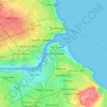
Nom : Carte topographique South Shields, altitude, relief.
Altitude moyenne : 23 m
Altitude minimum : -2 m
Altitude maximum : 82 m
Faire un don
Équipez-vous pour votre prochaine aventure :
En tant que Partenaire Amazon, ce site perçoit une commission sur les achats éligibles sans surcoût pour vous.