
Faire un don
Équipez-vous pour votre prochaine aventure :
En tant que Partenaire Amazon, ce site perçoit une commission sur les achats éligibles sans surcoût pour vous.
Carte topographique Friuli-Venezia Giulia
Cliquez sur la carte pour afficher l’altitude.
Faire un don
Équipez-vous pour votre prochaine aventure :
En tant que Partenaire Amazon, ce site perçoit une commission sur les achats éligibles sans surcoût pour vous.
Friuli-Venezia Giulia
To the west, the coast is shallow and sandy, with numerous tourist resorts and the lagoons of Grado and Marano Lagunare. To the east, the coastline rises into cliffs, where the Karst Plateau meets the Adriatic, all the way to Trieste and Muggia on the border with Slovenia. The Carso has geological features and phenomena such as hollows, cave networks, and underground rivers, which extend inland in the provinces of Trieste and Gorizia, with an altitude ranging between 300m and 600m.
Faire un don
Équipez-vous pour votre prochaine aventure :
En tant que Partenaire Amazon, ce site perçoit une commission sur les achats éligibles sans surcoût pour vous.
À propos de cette carte
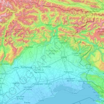
Nom : Carte topographique Friuli-Venezia Giulia, altitude, relief.
Lieu : Friuli-Venezia Giulia, Italy (45.58090 12.32138 46.64795 13.91866)
Altitude moyenne : 588 m
Altitude minimum : -5 m
Altitude maximum : 3 072 m
Faire un don
Équipez-vous pour votre prochaine aventure :
En tant que Partenaire Amazon, ce site perçoit une commission sur les achats éligibles sans surcoût pour vous.
Autres cartes topographiques
Cliquez sur une carte pour visualiser sa topographie, son altitude et son relief.
Faire un don
Équipez-vous pour votre prochaine aventure :
En tant que Partenaire Amazon, ce site perçoit une commission sur les achats éligibles sans surcoût pour vous.
Faire un don
Équipez-vous pour votre prochaine aventure :
En tant que Partenaire Amazon, ce site perçoit une commission sur les achats éligibles sans surcoût pour vous.
Mount Vesuvius
Italy > Campania > Naples > Trecase
The volcano's slopes are scarred by lava flows, while the rest are heavily vegetated, with scrub and forests at higher altitudes and vineyards lower down.
Altitude moyenne : 862 m
Faire un don
Équipez-vous pour votre prochaine aventure :
En tant que Partenaire Amazon, ce site perçoit une commission sur les achats éligibles sans surcoût pour vous.
Faire un don
Équipez-vous pour votre prochaine aventure :
En tant que Partenaire Amazon, ce site perçoit une commission sur les achats éligibles sans surcoût pour vous.
Faire un don
Équipez-vous pour votre prochaine aventure :
En tant que Partenaire Amazon, ce site perçoit une commission sur les achats éligibles sans surcoût pour vous.
Vetzan - Vezzano
Italy > Trentino-Alto Adige/Südtirol > South Tyrol > Schlanders - Silandro
Altitude moyenne : 978 m
Laimburg - Castel Varco
Italy > Trentino-Alto Adige/Südtirol > South Tyrol > Vadena - Pfatten
Altitude moyenne : 321 m
Faire un don
Équipez-vous pour votre prochaine aventure :
En tant que Partenaire Amazon, ce site perçoit une commission sur les achats éligibles sans surcoût pour vous.
Muls
Italy > Trentino-Alto Adige/Südtirol > South Tyrol > Sarntal - Sarentino
Altitude moyenne : 1 678 m
Faire un don
Équipez-vous pour votre prochaine aventure :
En tant que Partenaire Amazon, ce site perçoit une commission sur les achats éligibles sans surcoût pour vous.
Rolle Pass
Italy > Trentino – Alto Adige/Südtirol > Provincia di Trento > San Martino di Castrozza
Due to altitude, the climate is subarctic (Köppen: Dfc), similar to other high mountains in the Alps. The annual average temperature is 3.2 °C (37.8 °F), the hottest month in July is 11.8 °C (53.2 °F), and the coldest month is −4.4 °C (24.1 °F) in February. The annual precipitation is 1,004.11…
Altitude moyenne : 1 996 m
Faire un don
Équipez-vous pour votre prochaine aventure :
En tant que Partenaire Amazon, ce site perçoit une commission sur les achats éligibles sans surcoût pour vous.
Faire un don
Équipez-vous pour votre prochaine aventure :
En tant que Partenaire Amazon, ce site perçoit une commission sur les achats éligibles sans surcoût pour vous.
Faire un don
Équipez-vous pour votre prochaine aventure :
En tant que Partenaire Amazon, ce site perçoit une commission sur les achats éligibles sans surcoût pour vous.
San Rocco Castagnaretta
Italy > Piedmont > Cuneo > Cuneo > San Rocco Castagnaretta
Altitude moyenne : 569 m
Urban
Italy > Trentino-Alto Adige/Südtirol > Unsere Liebe Frau im Walde-St. Felix - Senale-San Felice > Unsere Liebe Frau im Walde - Senale > Urban
Altitude moyenne : 1 530 m
Baldal
Italy > Trentino-Alto Adige/Südtirol > Provincia di Trento > Palù del Fersina - Palai en Bersntol > Palai en Bersntol - Palù del Fersina
Altitude moyenne : 1 758 m
Faire un don
Équipez-vous pour votre prochaine aventure :
En tant que Partenaire Amazon, ce site perçoit une commission sur les achats éligibles sans surcoût pour vous.
Faire un don
Équipez-vous pour votre prochaine aventure :
En tant que Partenaire Amazon, ce site perçoit une commission sur les achats éligibles sans surcoût pour vous.
Palette
Italy > Trentino-Alto Adige/Südtirol > Provincia di Trento > Spiazzo
Altitude moyenne : 1 714 m
Faire un don
Équipez-vous pour votre prochaine aventure :
En tant que Partenaire Amazon, ce site perçoit une commission sur les achats éligibles sans surcoût pour vous.