
Faire un don
Équipez-vous pour votre prochaine aventure :
En tant que Partenaire Amazon, ce site perçoit une commission sur les achats éligibles sans surcoût pour vous.
Carte topographique Smethwick
Cliquez sur la carte pour afficher l’altitude.
Faire un don
Équipez-vous pour votre prochaine aventure :
En tant que Partenaire Amazon, ce site perçoit une commission sur les achats éligibles sans surcoût pour vous.
À propos de cette carte
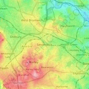
Nom : Carte topographique Smethwick, altitude, relief.
Altitude moyenne : 156 m
Altitude minimum : 95 m
Altitude maximum : 238 m
Faire un don
Équipez-vous pour votre prochaine aventure :
En tant que Partenaire Amazon, ce site perçoit une commission sur les achats éligibles sans surcoût pour vous.
Autres cartes topographiques
Cliquez sur une carte pour visualiser sa topographie, son altitude et son relief.
Rowley Hills
United Kingdom > England > Sandwell > Tividale
The largest hill, Turner's Hill, is the highest point in the West Midlands county, with an altitude of 269 metres (883 ft) above sea level. Views from the summit include the Clee Hills, Clent Hills, Cannock Chase, and much of Birmingham and the Black Country. The height has also led to the construction of two…
Altitude moyenne : 182 m
Causeway Green Park
United Kingdom > England > Sandwell > Causeway Green > The Ashes
Altitude moyenne : 184 m