
Carte topographique Village of Tannersville
Carte interactive
Cliquez sur la carte pour afficher l’altitude.
À propos de cette carte
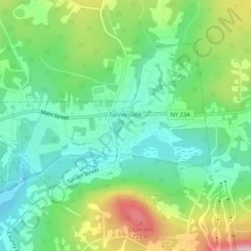
Nom : Carte topographique Village of Tannersville, altitude, relief.
Altitude moyenne : 613 m
Altitude minimum : 547 m
Altitude maximum : 742 m
Tannersville is located in southern Greene County at 42°11′37″N 74°8′20″W / 42.19361°N 74.13889°W / 42.19361; -74.13889 (42.193619, -74.139011), in the northern part of the town of Hunter. It is situated at an elevation of 1,900 feet (580 m) in the Catskill Mountains just west of the height of land on New York State Route 23A: Sawmill Creek flows southwest through the center of the village into Gooseberry Creek and thence into Schoharie Creek, a north-flowing tributary of the Mohawk River, while just 2 miles (3 km) to the east, at Haines Falls, Kaaterskill Creek drops east into Kaaterskill Clove and thence into the Hudson River valley.
Autres cartes topographiques
Cliquez sur une carte pour visualiser sa topographie, son altitude et son relief.
Sugarloaf Mountain
United States > New York > Greene County > Town of Hunter
Sugarloaf Mountain, Town of Hunter, Greene County, New York, United States
Altitude moyenne : 846 m