
Faire un don
Équipez-vous pour votre prochaine aventure :
En tant que Partenaire Amazon, ce site perçoit une commission sur les achats éligibles sans surcoût pour vous.
Carte topographique Byron
Cliquez sur la carte pour afficher l’altitude.
Faire un don
Équipez-vous pour votre prochaine aventure :
En tant que Partenaire Amazon, ce site perçoit une commission sur les achats éligibles sans surcoût pour vous.
Byron
Byron is located in Byron Township at the junction of Illinois Route 72 and Illinois Route 2. Byron's topography includes a man-made prairie and the Rock River that passes through the town. It is generally flat and is ideal for farming in most regions. According to the 2010 census, Byron has a total area of 3.572 square miles (9.25 km2), of which 3.57 square miles (9.25 km2) (or 99.94%) is land and 0.002 square miles (0.01 km2) (or 0.06%) is water.
Faire un don
Équipez-vous pour votre prochaine aventure :
En tant que Partenaire Amazon, ce site perçoit une commission sur les achats éligibles sans surcoût pour vous.
À propos de cette carte
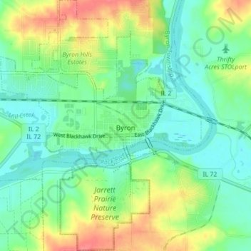
Nom : Carte topographique Byron, altitude, relief.
Altitude moyenne : 226 m
Altitude minimum : 204 m
Altitude maximum : 267 m
Faire un don
Équipez-vous pour votre prochaine aventure :
En tant que Partenaire Amazon, ce site perçoit une commission sur les achats éligibles sans surcoût pour vous.
Autres cartes topographiques
Cliquez sur une carte pour visualiser sa topographie, son altitude et son relief.