
Carte topographique Berkeley River
Cliquez sur la carte pour afficher l’altitude.
À propos de cette carte
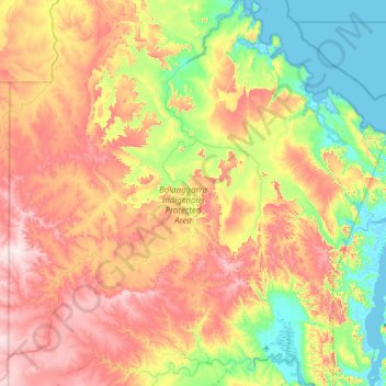
Nom : Carte topographique Berkeley River, altitude, relief.
Lieu : Berkeley River, Western Australia, Australia (-15.25222 127.18632 -14.34990 127.77814)
Altitude moyenne : 175 m
Altitude minimum : -2 m
Altitude maximum : 419 m
Autres cartes topographiques
Cliquez sur une carte pour visualiser sa topographie, son altitude et son relief.
Perth
Perth, the capital of Western Australia, is situated on the Swan Coastal Plain, a flat expanse of sandy soil nestled between the Indian Ocean to the west and the Darling Scarp to the east. The Darling Scarp, also known as the Darling Range, is a low escarpment that extends north–south, marking a distinct…
Altitude moyenne : 26 m
Nullarbor Plain
Australia > Western Australia > Forrest
One theory is that the whole area was uplifted by crustal movements in the Miocene, and since then, erosion by wind and rain has reduced its thickness. The plain has most likely never had any major defining topographic features, resulting in the extremely flat terrain across the plain today.
Altitude moyenne : 131 m
Rockingham
Australia > Western Australia > Rockingham
Rockingham is topographically flat, has sandy soils and coastal vegetation. It has a northern aspect to Cockburn Sound, from Rockingham Beach and Palm Beach.
Altitude moyenne : 4 m
Perth
Perth, the capital of Western Australia, is situated on the Swan Coastal Plain, a flat expanse of sandy soil nestled between the Indian Ocean to the west and the Darling Scarp to the east. The Darling Scarp, also known as the Darling Range, is a low escarpment that extends north–south, marking a distinct…
Altitude moyenne : 26 m
Mount Meharry
The summit of Mount Meharry can be reached from the Great Northern Highway via an unsealed road 16 kilometres (9.9 mi) in length and a vehicular track 21 kilometres (13 mi) in length. Permission should be sought from the managers of the land over which the road and track pass. These are Juna Downs Station and…
Altitude moyenne : 1 030 m