
Carte topographique Long Beach Island
Carte interactive
Cliquez sur la carte pour afficher l’altitude.
À propos de cette carte
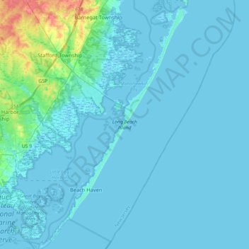
Nom : Carte topographique Long Beach Island, altitude, relief.
Altitude moyenne : 4 m
Altitude minimum : -3 m
Altitude maximum : 50 m
Autres cartes topographiques
Cliquez sur une carte pour visualiser sa topographie, son altitude et son relief.
Daniel Island
United States > New Jersey > Ocean County > Long Beach Township
Daniel Island, Long Beach Township, Ocean County, New Jersey, 08008, United States
Altitude moyenne : 8 m