
Carte topographique Clitheroe
Cliquez sur la carte pour afficher l’altitude.
À propos de cette carte
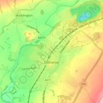
Nom : Carte topographique Clitheroe, altitude, relief.
Lieu : Clitheroe, Ribble Valley, Lancashire, England, United Kingdom (53.85666 -2.42473 53.89501 -2.35846)
Altitude moyenne : 84 m
Altitude minimum : 13 m
Altitude maximum : 167 m
Autres cartes topographiques
Cliquez sur une carte pour visualiser sa topographie, son altitude et son relief.
Billington and Langho
United Kingdom > England > Lancashire > Ribble Valley > Brockhall Village
Altitude moyenne : 58 m
Old Langho
United Kingdom > England > Lancashire > Ribble Valley > Brockhall Village
Altitude moyenne : 74 m
Brungerley Park
United Kingdom > England > Lancashire > Ribble Valley > Clitheroe > Waddington
Altitude moyenne : 77 m
Mellor Brook
United Kingdom > England > Lancashire > Ribble Valley > Mellor Brook
Altitude moyenne : 106 m