
Faire un don
Équipez-vous pour votre prochaine aventure :
En tant que Partenaire Amazon, ce site perçoit une commission sur les achats éligibles sans surcoût pour vous.
Carte topographique Indiantown
Cliquez sur la carte pour afficher l’altitude.
Faire un don
Équipez-vous pour votre prochaine aventure :
En tant que Partenaire Amazon, ce site perçoit une commission sur les achats éligibles sans surcoût pour vous.
Indiantown
Indiantown was originally established by the Seminole people as a trading post. Tribes fleeing southwards from the U.S. Army after the First Seminole War found the area an attractive place to settle due to a relatively higher elevation and ample hunting and fishing spots. It was then settled by white American migrants in the 1890s.
Faire un don
Équipez-vous pour votre prochaine aventure :
En tant que Partenaire Amazon, ce site perçoit une commission sur les achats éligibles sans surcoût pour vous.
À propos de cette carte
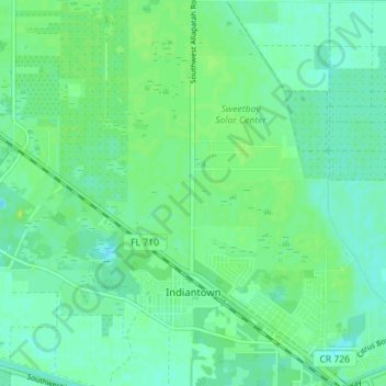
Nom : Carte topographique Indiantown, altitude, relief.
Lieu : Indiantown, Martin County, Florida, United States (27.01212 -80.49477 27.07483 -80.44188)
Altitude moyenne : 11 m
Altitude minimum : 4 m
Altitude maximum : 15 m
Faire un don
Équipez-vous pour votre prochaine aventure :
En tant que Partenaire Amazon, ce site perçoit une commission sur les achats éligibles sans surcoût pour vous.