
Carte topographique Padstow
Cliquez sur la carte pour afficher l’altitude.
À propos de cette carte
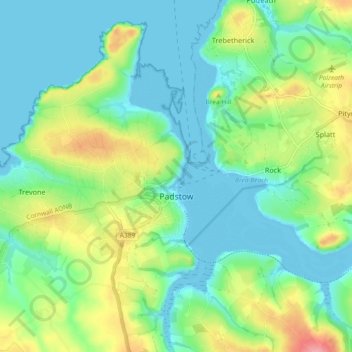
Nom : Carte topographique Padstow, altitude, relief.
Lieu : Padstow, Cornwall, England, United Kingdom (50.51459 -5.00009 50.57287 -4.93033)
Altitude moyenne : 29 m
Altitude minimum : 0 m
Altitude maximum : 97 m
Autres cartes topographiques
Cliquez sur une carte pour visualiser sa topographie, son altitude et son relief.
Bude
United Kingdom > England > Cornwall
Its earlier importance was as a harbour, and then a source of sea sand useful for improving the inland soil. This was transported on the Bude Canal. The Victorians favoured it as a seaside resort. With new rail links, it became a popular seaside destination in the 20th century. Bradshaw's Guide of 1866,…
Altitude moyenne : 41 m