
Carte topographique Forest of Bowland AONB
Carte interactive
Cliquez sur la carte pour afficher l’altitude.
À propos de cette carte
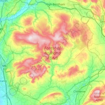
Nom : Carte topographique Forest of Bowland AONB, altitude, relief.
Lieu : Forest of Bowland AONB, Lancashire, England, United Kingdom (53.83311 -2.75988 54.12999 -2.27100)
Altitude moyenne : 201 m
Altitude minimum : 11 m
Altitude maximum : 560 m
Contrary to the popular histories, the origins of the name "Bowland" have nothing to do with archery ("the land of the bow") or with mediaeval cattle farms or vaccaries (Old Norse, buu-, farmstead). The name derives from the Old Norse boga-/bogi-, meaning a "bend in a river". It is a 10th-century coinage used to describe the topography of the Hodder basin, with its characteristic meandering river and brooks.
Autres cartes topographiques
Cliquez sur une carte pour visualiser sa topographie, son altitude et son relief.
Preston
United Kingdom > England > Lancashire
Preston, Lancashire, England, United Kingdom
Altitude moyenne : 58 m
Lancaster
United Kingdom > England > Lancashire
Lancaster, Lancashire, England, United Kingdom
Altitude moyenne : 84 m
Chorley
United Kingdom > England > Lancashire
Chorley, Lancashire, England, United Kingdom
Altitude moyenne : 113 m
Burnley
United Kingdom > England > Lancashire
Burnley, Lancashire, England, United Kingdom
Altitude moyenne : 247 m
Hesketh Lane
United Kingdom > England > Lancashire > Ribble Valley
Hesketh Lane, Chipping, Ribble Valley, Lancashire, England, PR3 2TH, United Kingdom
Altitude moyenne : 131 m
Haggate
United Kingdom > England > Lancashire > Burnley
Haggate, Burnley, Lancashire, England, BB10 3QH, United Kingdom
Altitude moyenne : 220 m
Mellor
United Kingdom > England > Lancashire > Ribble Valley
Mellor, Ribble Valley, Lancashire, England, United Kingdom
Altitude moyenne : 139 m
Catlow
United Kingdom > England > Lancashire > Borough of Pendle > Nelson
Catlow, Nelson, Borough of Pendle, Lancashire, England, BB10 3RL, United Kingdom
Altitude moyenne : 243 m
Fence
United Kingdom > England > Lancashire > Borough of Pendle
Fence, Borough of Pendle, Lancashire, England, BB12 9EE, United Kingdom
Altitude moyenne : 187 m
Fold Head
United Kingdom > England > Lancashire > Borough of Rossendale > Healey
Fold Head, Whitworth, Healey, Borough of Rossendale, Lancashire, England, OL12 8XL, United Kingdom
Altitude moyenne : 294 m
Becconsall
United Kingdom > England > Lancashire > West Lancashire
Becconsall, West Lancashire, Lancashire, England, PR4 6SN, United Kingdom
Altitude moyenne : 10 m
Lower Bartle
United Kingdom > England > Lancashire > Preston > Woodplumpton
Lower Bartle, Woodplumpton, Preston, Lancashire, England, PR4 0RX, United Kingdom
Altitude moyenne : 30 m
Rivington Pike
United Kingdom > England > Lancashire > Horwich
Rivington Pike, Georges Lane, Rivington, Horwich, Chorley, Lancashire, Greater Manchester, England, BL6 6RU, United Kingdom
Altitude moyenne : 270 m
Borough of Fylde
United Kingdom > England > Lancashire
Borough of Fylde, Lancashire, England, United Kingdom
Altitude moyenne : 13 m
Borough of Rossendale
United Kingdom > England > Lancashire
Borough of Rossendale, Lancashire, England, United Kingdom
Altitude moyenne : 273 m
White Coppice
United Kingdom > England > Lancashire > Chorley
White Coppice, Anglezarke, Chorley, Lancashire, England, PR6 9DB, United Kingdom
Altitude moyenne : 184 m
Lancaster Canal
United Kingdom > England > Lancashire
Lancaster Canal, Lancashire, England, United Kingdom
Altitude moyenne : 98 m
Hardhorn
United Kingdom > England > Lancashire > Borough of Wyre
Hardhorn, Borough of Wyre, Lancashire, England, FY6 8DN, United Kingdom
Altitude moyenne : 13 m
Little Thornton
United Kingdom > England > Lancashire > Borough of Wyre
Little Thornton, Borough of Wyre, Lancashire, England, FY5 5LU, United Kingdom
Altitude moyenne : 8 m
Silverdale
United Kingdom > England > Lancashire > Lancaster
Silverdale, Lancaster, Lancashire, England, United Kingdom
Altitude moyenne : 16 m
Samlesbury
United Kingdom > England > Lancashire > South Ribble
Samlesbury, South Ribble, Lancashire, England, United Kingdom
Altitude moyenne : 58 m
Arkholme
United Kingdom > England > Lancashire > Lancaster
Arkholme, Lancaster, Lancashire, England, LA6 1RA, United Kingdom
Altitude moyenne : 57 m
Read
United Kingdom > England > Lancashire > Ribble Valley
Read, Ribble Valley, Lancashire, England, United Kingdom
Altitude moyenne : 114 m
Stodday
United Kingdom > England > Lancashire > Lancaster
Stodday, Aldcliffe-with-Stodday, Lancaster, Lancashire, England, LA2 0AG, United Kingdom
Altitude moyenne : 26 m
Over Kellet
United Kingdom > England > Lancashire > Lancaster
Over Kellet, Lancaster, Lancashire, England, United Kingdom
Altitude moyenne : 69 m
Whitewell Bottom
United Kingdom > England > Lancashire > Borough of Rossendale > Sagar Holme
Whitewell Bottom, Sagar Holme, Borough of Rossendale, Lancashire, England, BB4 9DE, United Kingdom
Altitude moyenne : 281 m
Gisburn
United Kingdom > England > Lancashire > Ribble Valley
Gisburn, Ribble Valley, Lancashire, England, United Kingdom
Altitude moyenne : 160 m
Hayshaw Fell
United Kingdom > England > Lancashire > Lancaster
Hayshaw Fell, Over Wyresdale, Lancaster, Lancashire, England, LA2 9DW, United Kingdom
Altitude moyenne : 226 m
Lytham St Annes
United Kingdom > England > Lancashire > Borough of Fylde
Lytham St Annes, Borough of Fylde, Lancashire, England, FY8 4AR, United Kingdom
Altitude moyenne : 5 m
Old Langho
United Kingdom > England > Lancashire > Ribble Valley > Brockhall Village
Old Langho, Billington and Langho, Brockhall Village, Ribble Valley, Lancashire, England, BB6 8AP, United Kingdom
Altitude moyenne : 74 m
Wray-with-Botton
United Kingdom > England > Lancashire > Lancaster
Wray-with-Botton, Lancaster, Lancashire, England, United Kingdom
Altitude moyenne : 261 m
Parlick
United Kingdom > England > Lancashire > Borough of Wyre
Parlick, Borough of Wyre, Lancashire, England, PR3 2NZ, United Kingdom
Altitude moyenne : 251 m
Warton Crag
United Kingdom > England > Lancashire > Lancaster > Warton
Warton Crag, Trig Point to Cleft Stone, Warton, Lancaster, Lancashire, England, LA5 9NE, United Kingdom
Altitude moyenne : 45 m
Billington and Langho
United Kingdom > England > Lancashire > Ribble Valley > Brockhall Village
Billington and Langho, Brockhall Village, Ribble Valley, Lancashire, England, United Kingdom, Chew Bank Wood
Altitude moyenne : 58 m
West Lancashire
United Kingdom > England > Lancashire
West Lancashire, Lancashire, England, United Kingdom
Altitude moyenne : 30 m
Brungerley Park
United Kingdom > England > Lancashire > Ribble Valley > Clitheroe > Waddington
Brungerley Park, Clitheroe, Waddington, Ribble Valley, Lancashire, England, United Kingdom
Altitude moyenne : 77 m
Warton Bank
United Kingdom > England > Lancashire > Borough of Fylde > Warton
Warton Bank, Bryning-with-Warton, Warton, Borough of Fylde, Lancashire, England, PR4 1TB, United Kingdom
Altitude moyenne : 8 m
Leyland
United Kingdom > England > Lancashire > South Ribble
Leyland, South Ribble, Lancashire, England, PR25 2EX, United Kingdom
Altitude moyenne : 41 m
Billington
United Kingdom > England > Lancashire > Ribble Valley
Billington, Ribble Valley, Lancashire, England, BB7 9NG, United Kingdom
Altitude moyenne : 89 m
Ewood Bridge
United Kingdom > England > Lancashire > Borough of Rossendale
Ewood Bridge, Borough of Rossendale, Lancashire, England, BB4 6LZ, United Kingdom
Altitude moyenne : 226 m
Whitewell
United Kingdom > England > Lancashire > Ribble Valley
Whitewell, Bowland Forest Low, Ribble Valley, Lancashire, England, BB7 3AT, United Kingdom
Altitude moyenne : 184 m
Ormskirk
United Kingdom > England > Lancashire > West Lancashire
Ormskirk, West Lancashire, Lancashire, England, L39 2XN, United Kingdom
Altitude moyenne : 39 m
Brookhouse
United Kingdom > England > Lancashire > Lancaster
Brookhouse, Lancaster, Lancashire, England, LA2 9PA, United Kingdom
Altitude moyenne : 82 m
Capernwray
United Kingdom > England > Lancashire > Lancaster
Capernwray, Over Kellet, Lancaster, Lancashire, England, LA6 1AE, United Kingdom
Altitude moyenne : 60 m
Farington Moss
United Kingdom > England > Lancashire > South Ribble
Farington Moss, South Ribble, Lancashire, England, PR26 6RD, United Kingdom
Altitude moyenne : 36 m
Poulton-le-Fylde
United Kingdom > England > Lancashire > Borough of Wyre
Poulton-le-Fylde, Borough of Wyre, Lancashire, England, FY6 7BL, United Kingdom
Altitude moyenne : 12 m
River Brock
United Kingdom > England > Lancashire > Borough of Wyre
River Brock, Borough of Wyre, Lancashire, England, United Kingdom
Altitude moyenne : 111 m
Walton-le-Dale
United Kingdom > England > Lancashire > South Ribble
Walton-le-Dale, South Ribble, Lancashire, England, PR5 4BA, United Kingdom
Altitude moyenne : 31 m
Ash
United Kingdom > England > Lancashire > Preston
Ash, Water Head, Lane Ends, Ashton-on-Ribble, Preston, Lancashire, England, PR2 3TU, United Kingdom
Altitude moyenne : 28 m
Eccleston
United Kingdom > England > Lancashire > Chorley
Eccleston, Chorley, Lancashire, England, PR7 5TE, United Kingdom
Altitude moyenne : 36 m