
Carte topographique Appalachian National Scenic Trail
Carte interactive
Cliquez sur la carte pour afficher l’altitude.
À propos de cette carte
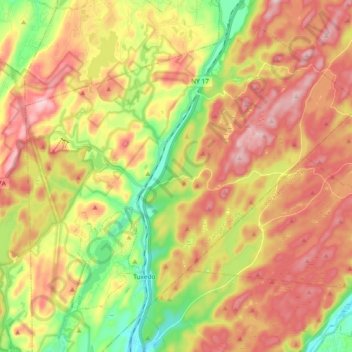
Nom : Carte topographique Appalachian National Scenic Trail, altitude, relief.
Altitude moyenne : 274 m
Altitude minimum : 113 m
Altitude maximum : 425 m
Plant life along the trail is varied. The trail passes through several different biomes from south to north, and the climate changes significantly, particularly dependent upon elevation. In the south, lowland forests consist mainly of second-growth; nearly the entire trail has been logged at one time or another. There are, however, a few old growth locations along the trail, such as Sages Ravine straddling the Massachusetts-Connecticut border and atop higher peaks along the trail on either side of the same border, the Hopper (a glacial cirque westward of the trail as it traverses Mt. Greylock in Massachusetts), and "The Hermitage", near Gulf Hagas in Maine. In the south, the forest is dominated by hardwoods, including oak and tulip trees, also known as yellow poplar. Farther north, tulip trees are gradually replaced by maples and birches. Oaks begin to disappear in Massachusetts. By Vermont, the lowland forest is made up of maples, birch and beech, with colorful foliage displays in September and October. While the vast majority of lowland forest south of the White Mountains is hardwood, many areas have some coniferous trees as well, and in Maine, these often grow at low elevations.