
Carte topographique West Ghent
Carte interactive
Cliquez sur la carte pour afficher l’altitude.
À propos de cette carte
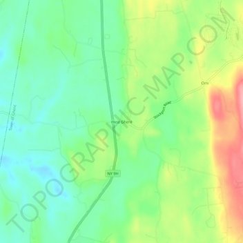
Nom : Carte topographique West Ghent, altitude, relief.
Altitude moyenne : 72 m
Altitude minimum : 32 m
Altitude maximum : 141 m
Autres cartes topographiques
Cliquez sur une carte pour visualiser sa topographie, son altitude et son relief.
Pulvers
United States > New York > Columbia County > Town of Ghent
Pulvers, Town of Ghent, Columbia County, New York, 12075, United States
Altitude moyenne : 111 m
Arnolds Mill
United States > New York > Columbia County > Town of Ghent
Arnolds Mill, Town of Ghent, Columbia County, New York, 12037, United States
Altitude moyenne : 178 m
Omi
United States > New York > Columbia County > Town of Ghent
Omi, Town of Ghent, Columbia County, New York, 12075, United States
Altitude moyenne : 93 m
Buckleyville
United States > New York > Columbia County > Town of Ghent
Buckleyville, Town of Ghent, Columbia County, New York, 12037, United States
Altitude moyenne : 157 m