
Faire un don
Équipez-vous pour votre prochaine aventure :
En tant que Partenaire Amazon, ce site perçoit une commission sur les achats éligibles sans surcoût pour vous.
Carte topographique Monroe Township
Cliquez sur la carte pour afficher l’altitude.
Faire un don
Équipez-vous pour votre prochaine aventure :
En tant que Partenaire Amazon, ce site perçoit une commission sur les achats éligibles sans surcoût pour vous.
À propos de cette carte
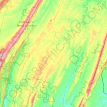
Nom : Carte topographique Monroe Township, altitude, relief.
Lieu : Monroe Township, Bedford County, Pennsylvania, United States (39.78952 -78.52087 39.96597 -78.26903)
Altitude moyenne : 407 m
Altitude minimum : 243 m
Altitude maximum : 707 m
Faire un don
Équipez-vous pour votre prochaine aventure :
En tant que Partenaire Amazon, ce site perçoit une commission sur les achats éligibles sans surcoût pour vous.
Autres cartes topographiques
Cliquez sur une carte pour visualiser sa topographie, son altitude et son relief.
New Enterprise
United States > Pennsylvania > Bedford County > South Woodbury Township
Altitude moyenne : 397 m
Blue Knob
United States > Pennsylvania > Bedford County > Pavia Township
Blue Knob (elevation 3,146 feet (959 m)) is a summit in the eastern United States with a broad dome that is the northernmost 3,000-footer in the Allegheny Mountains. It is the highest point in Bedford County, Pennsylvania.
Altitude moyenne : 792 m
Stiefler Corner
United States > Pennsylvania > Bedford County > Kimmel Township
Altitude moyenne : 520 m
Breezewood
United States > Pennsylvania > Bedford County > East Providence Township
Altitude moyenne : 413 m
Faire un don
Équipez-vous pour votre prochaine aventure :
En tant que Partenaire Amazon, ce site perçoit une commission sur les achats éligibles sans surcoût pour vous.
Texas Corner
United States > Pennsylvania > Bedford County > South Woodbury Township
Altitude moyenne : 462 m
Waterside
United States > Pennsylvania > Bedford County > South Woodbury Township
Altitude moyenne : 431 m
Yellow Creek
United States > Pennsylvania > Bedford County > Hopewell Township > Yellow Creek
Altitude moyenne : 323 m
Faire un don
Équipez-vous pour votre prochaine aventure :
En tant que Partenaire Amazon, ce site perçoit une commission sur les achats éligibles sans surcoût pour vous.
State Line
United States > Pennsylvania > Bedford County > Londonderry Township
Altitude moyenne : 329 m
Chaneysville
United States > Pennsylvania > Bedford County > Southampton Township
Altitude moyenne : 373 m
Faire un don
Équipez-vous pour votre prochaine aventure :
En tant que Partenaire Amazon, ce site perçoit une commission sur les achats éligibles sans surcoût pour vous.
Blue Knob
United States > Pennsylvania > Bedford County > Pavia Township
Blue Knob (elevation 3,146 feet (959 m)) is a summit in the eastern United States with a broad dome that is the northernmost 3,000-footer in the Allegheny Mountains. It is the highest point in Bedford County, Pennsylvania.
Altitude moyenne : 792 m