
Carte topographique Neufahrn bei Freising
Carte interactive
Cliquez sur la carte pour afficher l’altitude.
À propos de cette carte
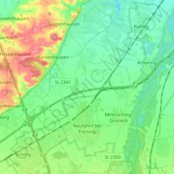
Nom : Carte topographique Neufahrn bei Freising, altitude, relief.
Lieu : Neufahrn bei Freising, Landkreis Freising, Bavaria, Germany (48.29025 11.59432 48.37624 11.70534)
Altitude moyenne : 464 m
Altitude minimum : 441 m
Altitude maximum : 514 m
Autres cartes topographiques
Cliquez sur une carte pour visualiser sa topographie, son altitude et son relief.
85413
Germany > Bavaria > Landkreis Freising > Margarethenried > Sixt in der Point
85413, Sixt in der Point, Margarethenried, Hörgertshausen, Mauern (VGem), Landkreis Freising, Bavaria, Germany
Altitude moyenne : 484 m
Dietersheim
Germany > Bavaria > Landkreis Freising
Dietersheim, Eching, Landkreis Freising, Bavaria, 85386, Germany
Altitude moyenne : 471 m
Günzenhausen
Germany > Bavaria > Landkreis Freising
Günzenhausen, Eching, Landkreis Freising, Bavaria, 85376, Germany
Altitude moyenne : 477 m
Mariabrunn
Germany > Bavaria > Landkreis Freising > Birkeneck
Mariabrunn, Birkeneck, Hallbergmoos, Landkreis Freising, Bavaria, 85399, Germany
Altitude moyenne : 453 m
Spörerau
Germany > Bavaria > Landkreis Freising > Wang
Spörerau, Wang, Mauern (VGem), Landkreis Freising, Bavaria, 84079, Germany
Altitude moyenne : 410 m
Freising
Germany > Bavaria > Landkreis Freising
Freising, Landkreis Freising, Bavaria, Germany
Altitude moyenne : 457 m
Moosburg
Germany > Bavaria > Landkreis Freising
Moosburg, Landkreis Freising, Bavaria, 85368, Germany
Altitude moyenne : 428 m