
Faire un don
Équipez-vous pour votre prochaine aventure :
En tant que Partenaire Amazon, ce site perçoit une commission sur les achats éligibles sans surcoût pour vous.
Carte topographique Mount Savage
Cliquez sur la carte pour afficher l’altitude.
Faire un don
Équipez-vous pour votre prochaine aventure :
En tant que Partenaire Amazon, ce site perçoit une commission sur les achats éligibles sans surcoût pour vous.
Mount Savage
A small blue-collar community, Mount Savage lies at the base of Big Savage Mountain in the Allegheny Mountains, between the cities of Frostburg and Cumberland. It began as a small farming settlement in the mid-19th century, but it was not until 1844 that the region was put on the nation's map with the pressing of the first iron rail in the United States. After this claim to fame, Mount Savage became the fifth largest city in Maryland. Named as the headquarters for the Mount Savage Railroad and later the Cumberland and Pennsylvania Railroad (C&P), the area was deemed an industrial center. In addition to the rail businesses, Mount Savage attracted a foundry, two brick refractories, and several local merchants. In this company town, the industries shaped the economy and topography of Mount Savage, building housing for workers and donating land for schools, churches, and other public buildings. It was a cultural melting pot attracting English businessmen and Irish, Scottish, Welsh, Italian, and German workers. With this diverse mix of cultures, the identity of Mount Savage was molded into a close-knit community. Despite the loss of the industries to the region, Mount Savage continues to celebrate its hard-working traditions. The Mount Savage Historic District was listed on the National Register of Historic Places in 1983.
Faire un don
Équipez-vous pour votre prochaine aventure :
En tant que Partenaire Amazon, ce site perçoit une commission sur les achats éligibles sans surcoût pour vous.
À propos de cette carte
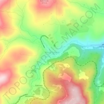
Nom : Carte topographique Mount Savage, altitude, relief.
Altitude moyenne : 476 m
Altitude minimum : 316 m
Altitude maximum : 639 m
Faire un don
Équipez-vous pour votre prochaine aventure :
En tant que Partenaire Amazon, ce site perçoit une commission sur les achats éligibles sans surcoût pour vous.
Autres cartes topographiques
Cliquez sur une carte pour visualiser sa topographie, son altitude et son relief.
Shaft
United States > Maryland > Allegany County > Borden Shaft > Braddock Estates
Shaft is a census-designated place (CDP) corresponding to the unincorporated community of Borden Shaft in Allegany County, Maryland, United States. As of the 2010 census, the CDP had a population of 235. It is located south of Frostburg, in the Georges Creek Valley. It lies at an elevation of 1,795 feet (547…
Altitude moyenne : 588 m
Lavale Community Park
United States > Maryland > Allegany County > Allegany Grove
Altitude moyenne : 354 m
Faire un don
Équipez-vous pour votre prochaine aventure :
En tant que Partenaire Amazon, ce site perçoit une commission sur les achats éligibles sans surcoût pour vous.
Rawlings
United States > Maryland > Allegany County > Rawlings > Rawlings Heights
Altitude moyenne : 262 m
Faire un don
Équipez-vous pour votre prochaine aventure :
En tant que Partenaire Amazon, ce site perçoit une commission sur les achats éligibles sans surcoût pour vous.
County Fairgrounds
United States > Maryland > Allegany County > Potomac Park > Cedar Cliff
Altitude moyenne : 274 m
Faire un don
Équipez-vous pour votre prochaine aventure :
En tant que Partenaire Amazon, ce site perçoit une commission sur les achats éligibles sans surcoût pour vous.