
Faire un don
Équipez-vous pour votre prochaine aventure :
En tant que Partenaire Amazon, ce site perçoit une commission sur les achats éligibles sans surcoût pour vous.
Carte topographique Bathwick Hill
Cliquez sur la carte pour afficher l’altitude.
Faire un don
Équipez-vous pour votre prochaine aventure :
En tant que Partenaire Amazon, ce site perçoit une commission sur les achats éligibles sans surcoût pour vous.
Bathwick Hill
Number 1 (Bathwick Lodge) is a 2-storey villa with a steep Mansard room, built in 1825, extended in 1840 and the late C19. Probably by John Pinch the Elder.[4] Number 2 is from the early 19th century and has shutters over the windows.[11] Number 3 includes a porch which is elaborately enriched with carving, Neo-Grecian gate posts and wrought iron gates.[12] Number 4 has a parapet which sweeps up to central balustrade with a rococo flourish,[13] as does number 5 which is also known as Cornwall Lodge.[14] Number 6, which is also known as Willow House, includes a wrought iron verandah on the 1st floor. Number 7 has a shallow hipped roof.[15] Number 8 has also been known as Upsala Villa[16] and later as Mendip Lodge.[17] The road elevation of number 9, built in 1820, extended in 1870, presents half an octagon in plan with overhanging eaves.[18]
Faire un don
Équipez-vous pour votre prochaine aventure :
En tant que Partenaire Amazon, ce site perçoit une commission sur les achats éligibles sans surcoût pour vous.
À propos de cette carte
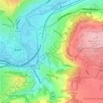
Nom : Carte topographique Bathwick Hill, altitude, relief.
Altitude moyenne : 93 m
Altitude minimum : 16 m
Altitude maximum : 208 m
Faire un don
Équipez-vous pour votre prochaine aventure :
En tant que Partenaire Amazon, ce site perçoit une commission sur les achats éligibles sans surcoût pour vous.
Autres cartes topographiques
Cliquez sur une carte pour visualiser sa topographie, son altitude et son relief.