
Faire un don
Équipez-vous pour votre prochaine aventure :
En tant que Partenaire Amazon, ce site perçoit une commission sur les achats éligibles sans surcoût pour vous.
Carte topographique Ol Donyo Sabuk
Cliquez sur la carte pour afficher l’altitude.
Faire un don
Équipez-vous pour votre prochaine aventure :
En tant que Partenaire Amazon, ce site perçoit une commission sur les achats éligibles sans surcoût pour vous.
Ol Donyo Sabuk
The Fourteen Falls area is protected and equipped with a picnic site. as it has historical and religious importance both to the residents and Asian immigrants. The Asians use the site for recreation and spiritual rites, disposing of cremated ash in the river in the belief that it will go all the way to India through the Indian Ocean, hence acting as a shrine. Others come for recreation, retaining the Happy Valley theme that was first introduced by Lord McMillan. Like Lord McMillan, the adjacent community, some of whom are descendants of the people the adventurer brought here, still farm the land. Fourteen Falls is located just a little bit away from Thika town. The falls are geographically situated at an altitude of approximately 1400 metres above sea level.
Faire un don
Équipez-vous pour votre prochaine aventure :
En tant que Partenaire Amazon, ce site perçoit une commission sur les achats éligibles sans surcoût pour vous.
À propos de cette carte
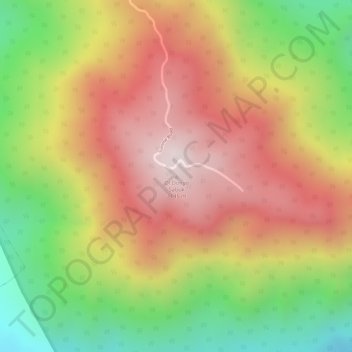
Nom : Carte topographique Ol Donyo Sabuk, altitude, relief.
Altitude moyenne : 1 866 m
Altitude minimum : 1 513 m
Altitude maximum : 2 145 m
Faire un don
Équipez-vous pour votre prochaine aventure :
En tant que Partenaire Amazon, ce site perçoit une commission sur les achats éligibles sans surcoût pour vous.