
Carte topographique Chesterfield Township
Carte interactive
Cliquez sur la carte pour afficher l’altitude.
À propos de cette carte
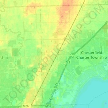
Nom : Carte topographique Chesterfield Township, altitude, relief.
Altitude moyenne : 184 m
Altitude minimum : 171 m
Altitude maximum : 200 m
Autres cartes topographiques
Cliquez sur une carte pour visualiser sa topographie, son altitude et son relief.
Harrison Charter Township
United States > Michigan > Macomb County
Harrison Charter Township, Macomb County, Michigan, United States
Altitude moyenne : 177 m
Lake Saint Clair
United States > Michigan > Macomb County
Lake Saint Clair, Macomb County, Michigan, United States
Altitude moyenne : 177 m
Roseville
United States > Michigan > Macomb County
Roseville, Macomb County, Michigan, 48066, United States
Altitude moyenne : 187 m
Washington Township
United States > Michigan > Macomb County
Washington Township, Macomb County, Michigan, 48095, United States
Altitude moyenne : 240 m