
Faire un don
Équipez-vous pour votre prochaine aventure :
En tant que Partenaire Amazon, ce site perçoit une commission sur les achats éligibles sans surcoût pour vous.
Carte topographique Luzerne County
Cliquez sur la carte pour afficher l’altitude.
Faire un don
Équipez-vous pour votre prochaine aventure :
En tant que Partenaire Amazon, ce site perçoit une commission sur les achats éligibles sans surcoût pour vous.
Luzerne County
The Wyoming Valley, also referred to as the Anthracite Valley Section of Pennsylvania, runs directly through Luzerne County. It extends from the northeastern border (with Lackawanna County) to the western border (with Columbia County). The valley is flat (at the Susquehanna Basin) and rises from 512 to 2,000 feet (156 to 610 m) in some places. Bear Creek, on the eastern side of the valley, has a mean elevation of about 2,000 feet (610 m), while Shickshinny, on the Susquehanna Basin, is about 512 feet (156 m). The county is crossed by a series of east-to-west mountains (e.g., Buck Mountain, Nescopeck Mountain, Penobscot Knob, and Red Rock Mountain). They are all part of the Appalachian Mountain Range.
Faire un don
Équipez-vous pour votre prochaine aventure :
En tant que Partenaire Amazon, ce site perçoit une commission sur les achats éligibles sans surcoût pour vous.
À propos de cette carte
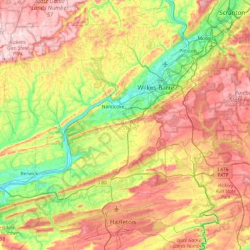
Nom : Carte topographique Luzerne County, altitude, relief.
Lieu : Luzerne County, Pennsylvania, United States (40.90222 -76.32010 41.42692 -75.60052)
Altitude moyenne : 402 m
Altitude minimum : 143 m
Altitude maximum : 750 m
Faire un don
Équipez-vous pour votre prochaine aventure :
En tant que Partenaire Amazon, ce site perçoit une commission sur les achats éligibles sans surcoût pour vous.
Autres cartes topographiques
Cliquez sur une carte pour visualiser sa topographie, son altitude et son relief.
Valley Forge
United States > Pennsylvania > Chester County > Schuylkill Township
Altitude moyenne : 78 m
Acme
United States > Pennsylvania > Westmoreland County > Mount Pleasant Township
Altitude moyenne : 585 m
East Texas
United States > Pennsylvania > Lehigh County > Lower Macungie Township
Altitude moyenne : 126 m
Faire un don
Équipez-vous pour votre prochaine aventure :
En tant que Partenaire Amazon, ce site perçoit une commission sur les achats éligibles sans surcoût pour vous.
Lake Keystone
United States > Pennsylvania > Armstrong County > Plumcreek Township
Keystone Lake (also known as Keystone Reservoir and Plum Creek Reservoir) is a reservoir in Armstrong County in the U.S. state of Pennsylvania. The elevation of Keystone Lake is 1,076 feet (328 m) above sea level.
Altitude moyenne : 357 m
Starview
United States > Pennsylvania > York County > East Manchester Township
Altitude moyenne : 155 m
Albrightsville
United States > Pennsylvania > Carbon County > Kidder Township
Altitude moyenne : 498 m
Faire un don
Équipez-vous pour votre prochaine aventure :
En tant que Partenaire Amazon, ce site perçoit une commission sur les achats éligibles sans surcoût pour vous.
Brackney
United States > Pennsylvania > Susquehanna County > Silver Lake Township
Altitude moyenne : 491 m
Dingmans Ferry
United States > Pennsylvania > Pike County > Delaware Township
Altitude moyenne : 192 m
Champion
United States > Pennsylvania > Allegheny County > North Fayette Township
Altitude moyenne : 360 m
Faire un don
Équipez-vous pour votre prochaine aventure :
En tant que Partenaire Amazon, ce site perçoit une commission sur les achats éligibles sans surcoût pour vous.
Middlebury Center
United States > Pennsylvania > Tioga County > Middlebury Township
Altitude moyenne : 462 m
Woxall
United States > Pennsylvania > Montgomery County > Upper Salford Township
Altitude moyenne : 98 m
Faire un don
Équipez-vous pour votre prochaine aventure :
En tant que Partenaire Amazon, ce site perçoit une commission sur les achats éligibles sans surcoût pour vous.
Donegal Lake
United States > Pennsylvania > Westmoreland County > Donegal Township
Altitude moyenne : 493 m
Centreville
United States > Pennsylvania > Lehigh County > Lower Macungie Township
Altitude moyenne : 144 m
Bass Lake
United States > Pennsylvania > York County > Newberry Township > Valley Green
Altitude moyenne : 143 m
Faire un don
Équipez-vous pour votre prochaine aventure :
En tant que Partenaire Amazon, ce site perçoit une commission sur les achats éligibles sans surcoût pour vous.
Croydon Heights
United States > Pennsylvania > Bucks County > Bristol Township > Croydon
Altitude moyenne : 10 m
Fitzwatertown
United States > Pennsylvania > Montgomery County > Upper Dublin Township
Altitude moyenne : 86 m
North Towanda
United States > Pennsylvania > Bradford County > North Towanda Township
Altitude moyenne : 286 m
Faire un don
Équipez-vous pour votre prochaine aventure :
En tant que Partenaire Amazon, ce site perçoit une commission sur les achats éligibles sans surcoût pour vous.
Faire un don
Équipez-vous pour votre prochaine aventure :
En tant que Partenaire Amazon, ce site perçoit une commission sur les achats éligibles sans surcoût pour vous.
Faire un don
Équipez-vous pour votre prochaine aventure :
En tant que Partenaire Amazon, ce site perçoit une commission sur les achats éligibles sans surcoût pour vous.
Freemont
United States > Pennsylvania > Chester County > West Nottingham Township
Altitude moyenne : 115 m
Sturgeon
United States > Pennsylvania > Allegheny County > North Fayette Township
Altitude moyenne : 334 m
Glade Mills
United States > Pennsylvania > Butler County > Middlesex Township
Altitude moyenne : 359 m
Faire un don
Équipez-vous pour votre prochaine aventure :
En tant que Partenaire Amazon, ce site perçoit une commission sur les achats éligibles sans surcoût pour vous.
Knickerbocker
United States > Pennsylvania > Chester County > Willistown Township
Altitude moyenne : 127 m
Carlisle Springs
United States > Pennsylvania > Cumberland County > Middlesex Township
Altitude moyenne : 182 m
Vance
United States > Pennsylvania > Washington County > South Strabane Township
Altitude moyenne : 371 m
Sagamore Estates
United States > Pennsylvania > Pike County > Shohola Township
Altitude moyenne : 412 m
Faire un don
Équipez-vous pour votre prochaine aventure :
En tant que Partenaire Amazon, ce site perçoit une commission sur les achats éligibles sans surcoût pour vous.
Evansburg State Park
United States > Pennsylvania > Montgomery County > Worcester Township > Cedars
Altitude moyenne : 70 m
Cross Fork
United States > Pennsylvania > Potter County > Stewardson Township
Altitude moyenne : 467 m
Faire un don
Équipez-vous pour votre prochaine aventure :
En tant que Partenaire Amazon, ce site perçoit une commission sur les achats éligibles sans surcoût pour vous.
Ithan
United States > Pennsylvania > Delaware County > Radnor Township > Saint Davids
Altitude moyenne : 116 m
Drumore Center
United States > Pennsylvania > Lancaster County > Drumore Township
Altitude moyenne : 175 m
Orefield
United States > Pennsylvania > Lehigh County > North Whitehall Township
Altitude moyenne : 141 m
Faire un don
Équipez-vous pour votre prochaine aventure :
En tant que Partenaire Amazon, ce site perçoit une commission sur les achats éligibles sans surcoût pour vous.
Mount Nebo Park
United States > Pennsylvania > Monroe County > East Stroudsburg > Twin Falls
Altitude moyenne : 185 m
Faire un don
Équipez-vous pour votre prochaine aventure :
En tant que Partenaire Amazon, ce site perçoit une commission sur les achats éligibles sans surcoût pour vous.
Reservoir Heights
United States > Pennsylvania > Dauphin County > Upper Paxton Township
Altitude moyenne : 189 m
Skytop
United States > Pennsylvania > Monroe County > Barrett Township
Skytop is an unincorporated community in Barrett Township, Monroe County, Pennsylvania, United States. Located north of Mountainhome, it is accessible by local roads off Route 390. Its elevation is 1,562 feet (476 m), and it is located at 41°13′40″N 75°14′18″W / 41.22778°N 75.23833°W /…
Altitude moyenne : 469 m
Mount Cobb
United States > Pennsylvania > Lackawanna County > Jefferson Township
Altitude moyenne : 529 m
Faire un don
Équipez-vous pour votre prochaine aventure :
En tant que Partenaire Amazon, ce site perçoit une commission sur les achats éligibles sans surcoût pour vous.
Pipersville
United States > Pennsylvania > Bucks County > Bedminster Township
Altitude moyenne : 125 m
Pastorius Park
United States > Pennsylvania > Philadelphia County > Philadelphia
Altitude moyenne : 108 m
Danielsville
United States > Pennsylvania > Northampton County > Lehigh Township
Altitude moyenne : 254 m
Faire un don
Équipez-vous pour votre prochaine aventure :
En tant que Partenaire Amazon, ce site perçoit une commission sur les achats éligibles sans surcoût pour vous.
Blue Mountain
United States > Pennsylvania > Monroe County > Eldred Township
The ridge of Blue Mountain runs for 150 miles (240 km) through Pennsylvania, reaching an elevation of 2,270 feet (690 m) above sea level just north of the Pennsylvania Turnpike, near the borough of Newburg. Most of the ridgecrest, however, only reaches between 1,400 and 1,700 feet (430 and 520 m) in elevation.…
Altitude moyenne : 242 m
Park Place
United States > Pennsylvania > Schuylkill County > Mahanoy Township
Altitude moyenne : 515 m
Faire un don
Équipez-vous pour votre prochaine aventure :
En tant que Partenaire Amazon, ce site perçoit une commission sur les achats éligibles sans surcoût pour vous.
Portlamd Waterfront Park
United States > Pennsylvania > Northampton County > Portland
Altitude moyenne : 118 m
Stevens Point
United States > Pennsylvania > Susquehanna County > Harmony Township
Altitude moyenne : 434 m
Faire un don
Équipez-vous pour votre prochaine aventure :
En tant que Partenaire Amazon, ce site perçoit une commission sur les achats éligibles sans surcoût pour vous.
Pendle Hill
United States > Pennsylvania > Delaware County > Nether Providence Township
Altitude moyenne : 61 m
Longwood Gardens
United States > Pennsylvania > Chester County > East Marlborough Township
Altitude moyenne : 125 m
Faire un don
Équipez-vous pour votre prochaine aventure :
En tant que Partenaire Amazon, ce site perçoit une commission sur les achats éligibles sans surcoût pour vous.
Nottingham County Park
United States > Pennsylvania > Chester County > West Nottingham Township
Altitude moyenne : 137 m
Marble Hall
United States > Pennsylvania > Montgomery County > Whitemarsh Township
Altitude moyenne : 64 m
Circleville
United States > Pennsylvania > Westmoreland County > North Huntingdon Township
Altitude moyenne : 333 m
Faire un don
Équipez-vous pour votre prochaine aventure :
En tant que Partenaire Amazon, ce site perçoit une commission sur les achats éligibles sans surcoût pour vous.
Chadds Ford Township
United States > Pennsylvania > Delaware County > Chadds Ford Township
Altitude moyenne : 101 m
Strawberry Mansion
United States > Pennsylvania > Philadelphia County > Philadelphia
Altitude moyenne : 31 m
Faire un don
Équipez-vous pour votre prochaine aventure :
En tant que Partenaire Amazon, ce site perçoit une commission sur les achats éligibles sans surcoût pour vous.
Reinholds
United States > Pennsylvania > Lancaster County > West Cocalico Township
Altitude moyenne : 159 m
Langhorne Gardens
United States > Pennsylvania > Bucks County > Middletown Township
Altitude moyenne : 45 m
Faire un don
Équipez-vous pour votre prochaine aventure :
En tant que Partenaire Amazon, ce site perçoit une commission sur les achats éligibles sans surcoût pour vous.
Hanover Junction
United States > Pennsylvania > York County > North Codorus Township
Altitude moyenne : 187 m
Faire un don
Équipez-vous pour votre prochaine aventure :
En tant que Partenaire Amazon, ce site perçoit une commission sur les achats éligibles sans surcoût pour vous.
North Coplay
United States > Pennsylvania > Lehigh County > Whitehall > Cementon
Altitude moyenne : 116 m
Fagleysville
United States > Pennsylvania > Montgomery County > New Hanover Township
Altitude moyenne : 105 m
Faire un don
Équipez-vous pour votre prochaine aventure :
En tant que Partenaire Amazon, ce site perçoit une commission sur les achats éligibles sans surcoût pour vous.
Kreidersville
United States > Pennsylvania > Northampton County > Allen Township
Altitude moyenne : 151 m
Faire un don
Équipez-vous pour votre prochaine aventure :
En tant que Partenaire Amazon, ce site perçoit une commission sur les achats éligibles sans surcoût pour vous.
Stiefler Corner
United States > Pennsylvania > Bedford County > Kimmel Township
Altitude moyenne : 520 m
Leather Corner Post
United States > Pennsylvania > Lehigh County > Lowhill Township
Altitude moyenne : 178 m
Welsh Mountain Nature Preserve
United States > Pennsylvania > Lancaster County > East Earl Township
Altitude moyenne : 294 m
Faire un don
Équipez-vous pour votre prochaine aventure :
En tant que Partenaire Amazon, ce site perçoit une commission sur les achats éligibles sans surcoût pour vous.