
Faire un don
Équipez-vous pour votre prochaine aventure :
En tant que Partenaire Amazon, ce site perçoit une commission sur les achats éligibles sans surcoût pour vous.
Carte topographique West Marion
Cliquez sur la carte pour afficher l’altitude.
Faire un don
Équipez-vous pour votre prochaine aventure :
En tant que Partenaire Amazon, ce site perçoit une commission sur les achats éligibles sans surcoût pour vous.
À propos de cette carte
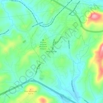
Nom : Carte topographique West Marion, altitude, relief.
Altitude moyenne : 449 m
Altitude minimum : 395 m
Altitude maximum : 592 m
Faire un don
Équipez-vous pour votre prochaine aventure :
En tant que Partenaire Amazon, ce site perçoit une commission sur les achats éligibles sans surcoût pour vous.
Autres cartes topographiques
Cliquez sur une carte pour visualiser sa topographie, son altitude et son relief.
Marion
United States > North Carolina > McDowell County
With an elevation of 1,400 feet, Marion's climate is fairly warm during summer (which are typically longer than lower elevation areas in the United States that get the same average high and low temperatures in the summer), when temperatures tend to be in the 80s and 90s, and moderately cold during the winter,…
Altitude moyenne : 435 m
Bobs Creek State Natural Area
United States > North Carolina > McDowell County
Altitude moyenne : 470 m
Marion
United States > North Carolina > McDowell County
With an elevation of 1,400 feet, Marion's climate is fairly warm during summer (which are typically longer than lower elevation areas in the United States that get the same average high and low temperatures in the summer), when temperatures tend to be in the 80s and 90s, and moderately cold during the winter,…
Altitude moyenne : 435 m
Faire un don
Équipez-vous pour votre prochaine aventure :
En tant que Partenaire Amazon, ce site perçoit une commission sur les achats éligibles sans surcoût pour vous.