
Faire un don
Équipez-vous pour votre prochaine aventure :
En tant que Partenaire Amazon, ce site perçoit une commission sur les achats éligibles sans surcoût pour vous.
Carte topographique Srinagar
Cliquez sur la carte pour afficher l’altitude.
Faire un don
Équipez-vous pour votre prochaine aventure :
En tant que Partenaire Amazon, ce site perçoit une commission sur les achats éligibles sans surcoût pour vous.
À propos de cette carte
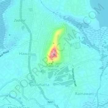
Nom : Carte topographique Srinagar, altitude, relief.
Altitude moyenne : 1 598 m
Altitude minimum : 1 580 m
Altitude maximum : 1 737 m
Faire un don
Équipez-vous pour votre prochaine aventure :
En tant que Partenaire Amazon, ce site perçoit une commission sur les achats éligibles sans surcoût pour vous.
Autres cartes topographiques
Cliquez sur une carte pour visualiser sa topographie, son altitude et son relief.
Dal Lake
India > Jammu and Kashmir > Srīnagar > Srinagar
The average elevation of the lake is 1,583 metres (5,194 ft). The depth of water varies from 6 metres (20 ft) at its deepest in Nigeen lake to 2.5 metres (8.2 ft), the shallowest at Gagribal. The depth ratio between the maximum and minimum depths varies with the season between 0.29 and 0.25, which is…
Altitude moyenne : 1 715 m