
Faire un don
Équipez-vous pour votre prochaine aventure :
En tant que Partenaire Amazon, ce site perçoit une commission sur les achats éligibles sans surcoût pour vous.
Carte topographique Pedro
Cliquez sur la carte pour afficher l’altitude.
Faire un don
Équipez-vous pour votre prochaine aventure :
En tant que Partenaire Amazon, ce site perçoit une commission sur les achats éligibles sans surcoût pour vous.
À propos de cette carte
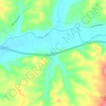
Nom : Carte topographique Pedro, altitude, relief.
Lieu : Pedro, Benton County, Arkansas, United States (36.14841 -94.42410 36.18841 -94.38410)
Altitude moyenne : 334 m
Altitude minimum : 295 m
Altitude maximum : 405 m
Faire un don
Équipez-vous pour votre prochaine aventure :
En tant que Partenaire Amazon, ce site perçoit une commission sur les achats éligibles sans surcoût pour vous.
Autres cartes topographiques
Cliquez sur une carte pour visualiser sa topographie, son altitude et son relief.
Beaver Lake
United States > Arkansas > Benton County > Goshen
Beaver Dam was authorized by the Flood Control Act of 1944 and other following acts. The United States Army Corps of Engineers constructed Beaver Dam during the years 1960-1966, impounding a major part of the White River and creating Beaver Lake and flooding much of the valley including the remains of the…
Altitude moyenne : 392 m
Faire un don
Équipez-vous pour votre prochaine aventure :
En tant que Partenaire Amazon, ce site perçoit une commission sur les achats éligibles sans surcoût pour vous.
Faire un don
Équipez-vous pour votre prochaine aventure :
En tant que Partenaire Amazon, ce site perçoit une commission sur les achats éligibles sans surcoût pour vous.
Benton Country Fair Grounds
United States > Arkansas > Benton County > Bentonville
Altitude moyenne : 384 m
Faire un don
Équipez-vous pour votre prochaine aventure :
En tant que Partenaire Amazon, ce site perçoit une commission sur les achats éligibles sans surcoût pour vous.
Faire un don
Équipez-vous pour votre prochaine aventure :
En tant que Partenaire Amazon, ce site perçoit une commission sur les achats éligibles sans surcoût pour vous.
Siloam Springs Lake
United States > Arkansas > Benton County > Siloam Springs
Altitude moyenne : 341 m