
Faire un don
Équipez-vous pour votre prochaine aventure :
En tant que Partenaire Amazon, ce site perçoit une commission sur les achats éligibles sans surcoût pour vous.
Carte topographique Sibu
Cliquez sur la carte pour afficher l’altitude.
Faire un don
Équipez-vous pour votre prochaine aventure :
En tant que Partenaire Amazon, ce site perçoit une commission sur les achats éligibles sans surcoût pour vous.
Sibu
Sibu is located near the Rajang delta at the confluence of Rajang and Igan rivers. Peat swamp forests and alluvial plains are particularly prevalent in the Sibu Division. Sibu is located on a deep peat soil, which has caused problems in infrastructure development because buildings and roads slowly sink into the ground after its completion. The location of Sibu in lowland peat swamps have subjected it to frequent floods, about 1 to 3 times per year. Because of these factors, the Sibu Flood Mitigation project was started to relieve the area from the floods. The highest elevation in Sibu is at Bukit Aup Jubilee Park, measuring 59 m above sea level.
Faire un don
Équipez-vous pour votre prochaine aventure :
En tant que Partenaire Amazon, ce site perçoit une commission sur les achats éligibles sans surcoût pour vous.
À propos de cette carte
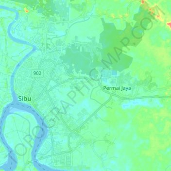
Nom : Carte topographique Sibu, altitude, relief.
Lieu : Sibu, Sibu Division, Sarawak, 96000, Malaysia (2.23627 111.81461 2.36353 111.92486)
Altitude moyenne : 9 m
Altitude minimum : -4 m
Altitude maximum : 46 m
Faire un don
Équipez-vous pour votre prochaine aventure :
En tant que Partenaire Amazon, ce site perçoit une commission sur les achats éligibles sans surcoût pour vous.
Autres cartes topographiques
Cliquez sur une carte pour visualiser sa topographie, son altitude et son relief.