
Faire un don
Équipez-vous pour votre prochaine aventure :
En tant que Partenaire Amazon, ce site perçoit une commission sur les achats éligibles sans surcoût pour vous.
Carte topographique Una
Cliquez sur la carte pour afficher l’altitude.
Faire un don
Équipez-vous pour votre prochaine aventure :
En tant que Partenaire Amazon, ce site perçoit une commission sur les achats éligibles sans surcoût pour vous.
Una
Una is located on the bank of the Machchundri river. It has an average elevation of 14 metres (46 feet). Kodinar is located to the west, and Diu is to the south. Una has the highest number of villages of all the Talukas in Gujarat state.
Faire un don
Équipez-vous pour votre prochaine aventure :
En tant que Partenaire Amazon, ce site perçoit une commission sur les achats éligibles sans surcoût pour vous.
À propos de cette carte
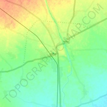
Nom : Carte topographique Una, altitude, relief.
Lieu : Una, Una Taluka, Gir Somnath, Gujarat, 362560, India (20.77989 70.99916 20.85989 71.07916)
Altitude moyenne : 25 m
Altitude minimum : 8 m
Altitude maximum : 48 m
Faire un don
Équipez-vous pour votre prochaine aventure :
En tant que Partenaire Amazon, ce site perçoit une commission sur les achats éligibles sans surcoût pour vous.