
Faire un don
Équipez-vous pour votre prochaine aventure :
En tant que Partenaire Amazon, ce site perçoit une commission sur les achats éligibles sans surcoût pour vous.
Carte topographique Markersbach
Cliquez sur la carte pour afficher l’altitude.
Faire un don
Équipez-vous pour votre prochaine aventure :
En tant que Partenaire Amazon, ce site perçoit une commission sur les achats éligibles sans surcoût pour vous.
Markersbach
In 1889, Markersbach was connected to the railway line from Schwarzenberg to Annaberg, which was closed to passenger transport on 27 September 1997. The station lay in Mittweida’s municipal area and the platform signs read Mittweida-Markersbach. To overcome the great elevation differential, the railway's alignment takes it along a broad bow through the community. Furthermore, three bridges are needed to cross narrow dales.
Faire un don
Équipez-vous pour votre prochaine aventure :
En tant que Partenaire Amazon, ce site perçoit une commission sur les achats éligibles sans surcoût pour vous.
À propos de cette carte
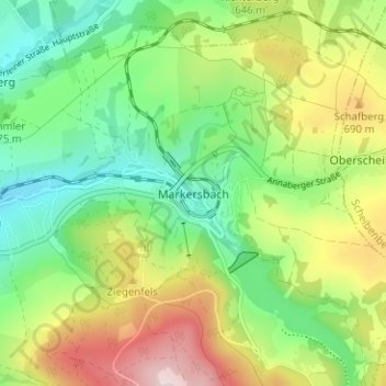
Nom : Carte topographique Markersbach, altitude, relief.
Altitude moyenne : 600 m
Altitude minimum : 461 m
Altitude maximum : 827 m
Faire un don
Équipez-vous pour votre prochaine aventure :
En tant que Partenaire Amazon, ce site perçoit une commission sur les achats éligibles sans surcoût pour vous.
Autres cartes topographiques
Cliquez sur une carte pour visualiser sa topographie, son altitude et son relief.
Faire un don
Équipez-vous pour votre prochaine aventure :
En tant que Partenaire Amazon, ce site perçoit une commission sur les achats éligibles sans surcoût pour vous.
Marienberg
Germany > Saxony > Erzgebirgskreis
The town is situated on a plateau north of the Ore Mountains ridge, at an elevation between 460 and 891 metres above sea level. It is approximately 31 kilometres south of Chemnitz, to which it is connected via the Flöha Valley Railway.
Altitude moyenne : 657 m
Faire un don
Équipez-vous pour votre prochaine aventure :
En tant que Partenaire Amazon, ce site perçoit une commission sur les achats éligibles sans surcoût pour vous.
Faire un don
Équipez-vous pour votre prochaine aventure :
En tant que Partenaire Amazon, ce site perçoit une commission sur les achats éligibles sans surcoût pour vous.