
Faire un don
Équipez-vous pour votre prochaine aventure :
En tant que Partenaire Amazon, ce site perçoit une commission sur les achats éligibles sans surcoût pour vous.
Carte topographique Devils Point
Cliquez sur la carte pour afficher l’altitude.
Faire un don
Équipez-vous pour votre prochaine aventure :
En tant que Partenaire Amazon, ce site perçoit une commission sur les achats éligibles sans surcoût pour vous.
À propos de cette carte
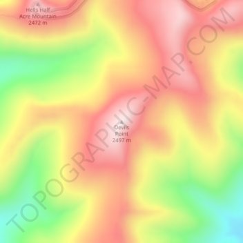
Nom : Carte topographique Devils Point, altitude, relief.
Lieu : Devils Point, Idaho County, Idaho, United States (45.63264 -114.61515 45.63274 -114.61505)
Altitude moyenne : 2 283 m
Altitude minimum : 1 985 m
Altitude maximum : 2 504 m
Faire un don
Équipez-vous pour votre prochaine aventure :
En tant que Partenaire Amazon, ce site perçoit une commission sur les achats éligibles sans surcoût pour vous.
Autres cartes topographiques
Cliquez sur une carte pour visualiser sa topographie, son altitude et son relief.
Coeur d'Alene
United States > Idaho > Kootenai County
The city is located on the north shore of Lake Coeur d'Alene, near the outlet of the Spokane River, and is in the Northern Rockies ecoregion. Lake Coeur d'Alene is a natural dam-controlled lake that is 25 miles (40 km) long and 1 mile (1.6 km) to 3 miles (4.8 km) wide and fed by the Coeur d'Alene and Saint Joe…
Altitude moyenne : 719 m
Moscow
United States > Idaho > Latah County
Along with the rest of the Idaho Panhandle, Moscow is in the Pacific Time Zone. The elevation of its city center is 2,579 feet (786 m) above sea level. Two major highways serve the city, passing through the city center: US-95 (north-south) and ID-8 (east-west). The Pullman–Moscow Regional Airport, four miles…
Altitude moyenne : 804 m
Faire un don
Équipez-vous pour votre prochaine aventure :
En tant que Partenaire Amazon, ce site perçoit une commission sur les achats éligibles sans surcoût pour vous.
Owyhee County
Nearly all of the county is high intermountain desert, with plentiful sagebrush and basalt canyons. The Owyhee Mountains in the west dominate the landscape, with Hayden Peak reaching 8,403 feet (2,561 m) above sea level. The lowest elevation is at the county's northwest corner, where the Snake River is just…
Altitude moyenne : 1 372 m
Sun Valley
United States > Idaho > Blaine County
Sun Valley is a resort city in the western United States, in Blaine County, Idaho, adjacent to the city of Ketchum in the Wood River valley. The population was 1406 at the 2010 census, down from 1427 in 2000. The elevation of Sun Valley (at the Lodge) is 5,920 feet (1,805 m) above sea level.
Altitude moyenne : 1 988 m
Faire un don
Équipez-vous pour votre prochaine aventure :
En tant que Partenaire Amazon, ce site perçoit une commission sur les achats éligibles sans surcoût pour vous.
Cassia County
According to the U.S. Census Bureau, the county has a total area of 2,580 square miles (6,700 km2), of which 2,565 square miles (6,640 km2) is land and 15 square miles (39 km2) (0.6%) is water. The county's highest point is Cache Peak at an elevation of 10,339 feet (3,151 m) above sea level in the Albion…
Altitude moyenne : 1 583 m
Minidoka County
It is part of the Magic Valley region of the Snake River Plain. Irrigated farmland covers the southern part of the county, while lava beds cover the northern portion. The elevation is generally in the range of 4,200 to 4,500 feet (1,300 to 1,400 m). The Snake River forms the county's southern boundary.
Altitude moyenne : 1 359 m
Faire un don
Équipez-vous pour votre prochaine aventure :
En tant que Partenaire Amazon, ce site perçoit une commission sur les achats éligibles sans surcoût pour vous.
Faire un don
Équipez-vous pour votre prochaine aventure :
En tant que Partenaire Amazon, ce site perçoit une commission sur les achats éligibles sans surcoût pour vous.
Oneida County
Oxford Peak is the highest point in the county at 9,285 ft (2,830 m) above sea level. Alternating valleys and ridges of mountains or hills typify the topography, with grassland and sagebrush covering most areas. The Curlew National Grassland lies within the county.
Altitude moyenne : 1 678 m
Faire un don
Équipez-vous pour votre prochaine aventure :
En tant que Partenaire Amazon, ce site perçoit une commission sur les achats éligibles sans surcoût pour vous.
Bear Lake County
The county is named after Bear Lake, a large lake at an elevation of 5,924 feet (1,806 m) above sea level. The northern half of the 20-mile-long (32-kilometer) lake is in Idaho, the southern half in Utah. The county was established in 1875 in the Idaho Territory, fifteen years before statehood.
Altitude moyenne : 2 095 m
Camas County
U.S. Highway 20 runs east–west through the county's center, at elevations just over 5,000 feet (1,520 m) above sea level, connecting west to Mountain Home in Elmore County; to the east it intersects State Highway 75 in Blaine County. The northern terminus of State Highway 46 is at US-20, four miles (6.4 km)…
Altitude moyenne : 2 002 m
Faire un don
Équipez-vous pour votre prochaine aventure :
En tant que Partenaire Amazon, ce site perçoit une commission sur les achats éligibles sans surcoût pour vous.
Faire un don
Équipez-vous pour votre prochaine aventure :
En tant que Partenaire Amazon, ce site perçoit une commission sur les achats éligibles sans surcoût pour vous.
Elmore County
According to the U.S. Census Bureau, the county has a total area of 3,101 square miles (8,030 km2), of which 3,075 square miles (7,960 km2) is land and 26 square miles (67 km2) (0.8%) is water. Elmore County's highest point is Snowyside Peak at 10,651 feet (3,246 m) above sea level, located in the northeast…
Altitude moyenne : 1 441 m
Boise County
The Boise Basin, which contains Idaho City, was one of the nation's richest gold mining districts; gold was discovered in 1862, and more of it was pulled from present-day Boise County than from the entire state of Alaska. At its peak in the mid-1860s, Idaho City was the largest city in the Northwest, and it…
Altitude moyenne : 1 655 m
Faire un don
Équipez-vous pour votre prochaine aventure :
En tant que Partenaire Amazon, ce site perçoit une commission sur les achats éligibles sans surcoût pour vous.
Faire un don
Équipez-vous pour votre prochaine aventure :
En tant que Partenaire Amazon, ce site perçoit une commission sur les achats éligibles sans surcoût pour vous.
Faire un don
Équipez-vous pour votre prochaine aventure :
En tant que Partenaire Amazon, ce site perçoit une commission sur les achats éligibles sans surcoût pour vous.
Faire un don
Équipez-vous pour votre prochaine aventure :
En tant que Partenaire Amazon, ce site perçoit une commission sur les achats éligibles sans surcoût pour vous.
Bonner County
According to the U.S. Census Bureau, the county has a total area of 1,919 square miles (4,970 km2), of which 1,735 square miles (4,490 km2) is land and 185 square miles (480 km2) (9.6%) is water. The highest point in the county is Scotchman Peak, elevation 7,018 feet (2,139 m).
Altitude moyenne : 1 052 m
Pocatello
United States > Idaho > Bannock County
Pocatello is the fifth-largest city in the state, just behind Idaho Falls. In 2007, Pocatello was ranked twentieth on Forbes list of Best Small Places for Business and Careers. Pocatello is the home of Idaho State University and the manufacturing facility of ON Semiconductor. The city is at an elevation of…
Altitude moyenne : 1 580 m
Faire un don
Équipez-vous pour votre prochaine aventure :
En tant que Partenaire Amazon, ce site perçoit une commission sur les achats éligibles sans surcoût pour vous.
Star
United States > Idaho > Ada County
Star is located at 43°41′39″N 116°29′25″W / 43.69417°N 116.49028°W / 43.69417; -116.49028 (43.694084, -116.490225), at an elevation of 2,470 feet (753 m) above sea level. According to the United States Census Bureau, the city has a total area of 5.86 square miles (15.18 km2), of which 5.82…
Altitude moyenne : 765 m
Faire un don
Équipez-vous pour votre prochaine aventure :
En tant que Partenaire Amazon, ce site perçoit une commission sur les achats éligibles sans surcoût pour vous.
Boise
United States > Idaho > Ada County
Boise (/ˈbɔɪziː/, BOYZ-ee; locally /ˈbɔɪsiː/ (listen), BOYSS-ee) is the capital and most populous city of the U.S. state of Idaho and is the county seat of Ada County. On the Boise River in southwestern Idaho, it is 41 miles (66 km) east of the Oregon border and 110 miles (177 km) north of the Nevada…
Altitude moyenne : 970 m
Coeur d'Alene
United States > Idaho > Kootenai County
The city is located on the north shore of Lake Coeur d'Alene, near the outlet of the Spokane River, and is in the Northern Rockies ecoregion. Lake Coeur d'Alene is a natural dam-controlled lake that is 25 miles (40 km) long and 1 mile (1.6 km) to 3 miles (4.8 km) wide and fed by the Coeur d'Alene and Saint Joe…
Altitude moyenne : 719 m
Faire un don
Équipez-vous pour votre prochaine aventure :
En tant que Partenaire Amazon, ce site perçoit une commission sur les achats éligibles sans surcoût pour vous.
Lewiston
United States > Idaho > Nez Perce County
According to the U.S. Census Bureau, the city has a total area of 18.04 square miles (46.72 km2), of which 17.23 square miles (44.63 km2) is land and 0.81 square miles (2.10 km2) is water. Downtown Lewiston, at elevations between 740 feet (230 m) and 780 feet (240 m), is only slightly higher in elevation than…
Altitude moyenne : 334 m
Island Park
United States > Idaho > Fremont County
Island Park is located at 44°29′59″N 111°20′19″W / 44.49972°N 111.33861°W / 44.49972; -111.33861 (44.4996, −111.3387), at an elevation of 6,293 feet (1,918 m) above sea level, making it the highest city in Idaho.
Altitude moyenne : 2 113 m
Post Falls
United States > Idaho > Kootenai County
Post Falls features a varied and distinctive topography characterized by its placement on the Rathdrum Prairie, which lies at an elevation of approximately 2,182 feet (665 meters) above sea level. This prairie is surrounded by rolling hills and rugged terrain that gradually rise towards the nearby Rocky…
Altitude moyenne : 710 m
Faire un don
Équipez-vous pour votre prochaine aventure :
En tant que Partenaire Amazon, ce site perçoit une commission sur les achats éligibles sans surcoût pour vous.
Faire un don
Équipez-vous pour votre prochaine aventure :
En tant que Partenaire Amazon, ce site perçoit une commission sur les achats éligibles sans surcoût pour vous.
Faire un don
Équipez-vous pour votre prochaine aventure :
En tant que Partenaire Amazon, ce site perçoit une commission sur les achats éligibles sans surcoût pour vous.
McCall
United States > Idaho > Valley County
McCall is located at 44°54′39″N 116°6′11″W / 44.91083°N 116.10306°W / 44.91083; -116.10306 (44.910906, -116.103087),[7] at an elevation of 5,013 feet (1,528 m) above sea level.
Altitude moyenne : 1 546 m
Faire un don
Équipez-vous pour votre prochaine aventure :
En tant que Partenaire Amazon, ce site perçoit une commission sur les achats éligibles sans surcoût pour vous.
Orofino
United States > Idaho > Clearwater County
The city has a climate typical of low-elevation areas in Idaho and eastern Washington. Orofino has a dry-summer continental climate (Köppen Dsb). Due to the warm summers, it nearly qualifies as a continental Mediterranean climate (Dsa). Idaho's all-time highest temperature of 118 °F or 47.8 °C was recorded…
Altitude moyenne : 633 m
Elmore County
According to the U.S. Census Bureau, the county has a total area of 3,101 square miles (8,030 km2), of which 3,075 square miles (7,960 km2) is land and 26 square miles (67 km2) (0.8%) is water. Elmore County's highest point is Snowyside Peak at 10,651 feet (3,246 m) above sea level, located in the northeast…
Altitude moyenne : 1 441 m
Faire un don
Équipez-vous pour votre prochaine aventure :
En tant que Partenaire Amazon, ce site perçoit une commission sur les achats éligibles sans surcoût pour vous.
Kamiah
United States > Idaho > Lewis County
The city is located at the confluence of Lawyer Creek and the Clearwater River on the left bank of the latter. In the Kamiah area, the Lewis-Idaho County line follows Lawyer Creek to its confluence with the Clearwater, and then turns to follow the Clearwater. U.S. Route 12 passes through Kamiah, crossing from…
Altitude moyenne : 399 m
Faire un don
Équipez-vous pour votre prochaine aventure :
En tant que Partenaire Amazon, ce site perçoit une commission sur les achats éligibles sans surcoût pour vous.
Faire un don
Équipez-vous pour votre prochaine aventure :
En tant que Partenaire Amazon, ce site perçoit une commission sur les achats éligibles sans surcoût pour vous.
Pocatello
United States > Idaho > Bannock County
The city is at an elevation of 4,462 feet (1,360 m) above sea level and it sits on the Portneuf River in the Snake River Plain ecoregion. Pocatello covers a land area of 33.36 square miles (86.4 square kilometers).
Altitude moyenne : 1 580 m
Faire un don
Équipez-vous pour votre prochaine aventure :
En tant que Partenaire Amazon, ce site perçoit une commission sur les achats éligibles sans surcoût pour vous.
Rexburg
United States > Idaho > Madison County
Rexburg is located at 43°49′N 111°47′W / 43.817°N 111.783°W / 43.817; -111.783, at an elevation of 4,865 feet (1,483 m) above sea level.
Altitude moyenne : 1 504 m
Pocatello
United States > Idaho > Bannock County
The city is at an elevation of 4,462 feet (1,360 m) above sea level and it sits on the Portneuf River in the Snake River Plain ecoregion. Pocatello covers a land area of 33.36 square miles (86.4 square kilometers).
Altitude moyenne : 1 580 m
Emmett
United States > Idaho > Gem County
According to the United States Census Bureau, the city has a total area of 2.82 square miles (7.30 km2), of which 2.80 square miles (7.25 km2) is land and 0.02 square miles (0.05 km2) is water. It is located south of the Payette River, at an elevation of 2,362 feet (720 m) above sea level.
Altitude moyenne : 738 m
Faire un don
Équipez-vous pour votre prochaine aventure :
En tant que Partenaire Amazon, ce site perçoit une commission sur les achats éligibles sans surcoût pour vous.
Arco
United States > Idaho > Butte County
Arco Peak, located two mile north of the community at an elevation of 7547 feet, rises 2220 feet above the city.
Altitude moyenne : 1 634 m
Faire un don
Équipez-vous pour votre prochaine aventure :
En tant que Partenaire Amazon, ce site perçoit une commission sur les achats éligibles sans surcoût pour vous.
Faire un don
Équipez-vous pour votre prochaine aventure :
En tant que Partenaire Amazon, ce site perçoit une commission sur les achats éligibles sans surcoût pour vous.