
Carte topographique Johnstown East
Carte interactive
Cliquez sur la carte pour afficher l’altitude.
À propos de cette carte
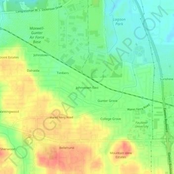
Nom : Carte topographique Johnstown East, altitude, relief.
Altitude moyenne : 73 m
Altitude minimum : 49 m
Altitude maximum : 100 m
Autres cartes topographiques
Cliquez sur une carte pour visualiser sa topographie, son altitude et son relief.
Mountain View Estates
United States > Alabama > Montgomery County > Montgomery
Mountain View Estates, Montgomery, Montgomery County, Alabama, 36109, United States
Altitude moyenne : 80 m
Carriage Hills
United States > Alabama > Montgomery County > Montgomery
Carriage Hills, Montgomery, Montgomery County, Alabama, 36116, United States
Altitude moyenne : 75 m
College Grove
United States > Alabama > Montgomery County > Montgomery
College Grove, Montgomery, Montgomery County, Alabama, 36109, United States
Altitude moyenne : 76 m
Southlawn
United States > Alabama > Montgomery County > Montgomery
Southlawn, Montgomery, Montgomery County, Alabama, 36105, United States
Altitude moyenne : 57 m
Bellwood Plantation
United States > Alabama > Montgomery County > Montgomery > Bellwood Plantation
Bellwood Plantation, Montgomery, Montgomery County, Alabama, 36123, United States
Altitude moyenne : 81 m
Mayfair
United States > Alabama > Montgomery County > Montgomery > Mayfair
Mayfair, Montgomery, Montgomery County, Alabama, 36109, United States
Altitude moyenne : 84 m
Regency Forest
United States > Alabama > Montgomery County > Montgomery > Regency Forest
Regency Forest, Montgomery, Montgomery County, Alabama, 36116, United States
Altitude moyenne : 67 m
Sunshine Village
United States > Alabama > Montgomery County > Montgomery > Sunshine Village
Sunshine Village, Montgomery, Montgomery County, Alabama, 36119, United States
Altitude moyenne : 65 m