
Faire un don
Équipez-vous pour votre prochaine aventure :
En tant que Partenaire Amazon, ce site perçoit une commission sur les achats éligibles sans surcoût pour vous.
Carte topographique Mount Sungay
Cliquez sur la carte pour afficher l’altitude.
Faire un don
Équipez-vous pour votre prochaine aventure :
En tant que Partenaire Amazon, ce site perçoit une commission sur les achats éligibles sans surcoût pour vous.
Mount Sungay
Mount Sungay is the eastern end of the Tagaytay Range, or more commonly known as the Tagaytay Ridge, a 32-kilometre (20 mi) ridge located at the southern part of the province with elevations averaging about 600 m (2,000 ft) above sea level. The ridge stretches west-southwest from Mount Sungay to Mount Batulao in Batangas province.
Faire un don
Équipez-vous pour votre prochaine aventure :
En tant que Partenaire Amazon, ce site perçoit une commission sur les achats éligibles sans surcoût pour vous.
À propos de cette carte
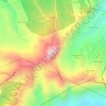
Nom : Carte topographique Mount Sungay, altitude, relief.
Altitude moyenne : 501 m
Altitude minimum : 264 m
Altitude maximum : 728 m
Faire un don
Équipez-vous pour votre prochaine aventure :
En tant que Partenaire Amazon, ce site perçoit une commission sur les achats éligibles sans surcoût pour vous.
Autres cartes topographiques
Cliquez sur une carte pour visualiser sa topographie, son altitude et son relief.