
Faire un don
Équipez-vous pour votre prochaine aventure :
En tant que Partenaire Amazon, ce site perçoit une commission sur les achats éligibles sans surcoût pour vous.
Carte topographique Pullman
Cliquez sur la carte pour afficher l’altitude.
Faire un don
Équipez-vous pour votre prochaine aventure :
En tant que Partenaire Amazon, ce site perçoit une commission sur les achats éligibles sans surcoût pour vous.
Pullman
The city is situated across several loess hills which characterize the Palouse Prairie, formed from windblown sediment over an estimated period of over one million years. This prairie region, the Palouse, is noteworthy for its fertile rolling hills where winter and spring wheat, barley, lentils, and peas are grown. These hills provide a variety of elevations across the city, from 2342 to 2575 ft (714 to 785 m) above sea level. Downtown Pullman is situated in a valley between these hills. Within the Pullman city limits, the Missouri Flat Creek and Paradise Creek both join the South Fork of the Palouse River. Pullman sits in the watersheds of the Snake River and the Columbia River.
Faire un don
Équipez-vous pour votre prochaine aventure :
En tant que Partenaire Amazon, ce site perçoit une commission sur les achats éligibles sans surcoût pour vous.
À propos de cette carte
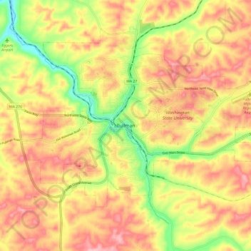
Nom : Carte topographique Pullman, altitude, relief.
Altitude moyenne : 774 m
Altitude minimum : 693 m
Altitude maximum : 832 m
Faire un don
Équipez-vous pour votre prochaine aventure :
En tant que Partenaire Amazon, ce site perçoit une commission sur les achats éligibles sans surcoût pour vous.