
Faire un don
Équipez-vous pour votre prochaine aventure :
En tant que Partenaire Amazon, ce site perçoit une commission sur les achats éligibles sans surcoût pour vous.
Carte topographique Allenton
Cliquez sur la carte pour afficher l’altitude.
Faire un don
Équipez-vous pour votre prochaine aventure :
En tant que Partenaire Amazon, ce site perçoit une commission sur les achats éligibles sans surcoût pour vous.
Allenton
Allenton is located at latitude 43.421 and longitude -88.341. The elevation is 958 feet. Allenton has an area of 1.446 square miles (3.75 km2), all of it land. The Rock River cuts through the town.
Faire un don
Équipez-vous pour votre prochaine aventure :
En tant que Partenaire Amazon, ce site perçoit une commission sur les achats éligibles sans surcoût pour vous.
À propos de cette carte
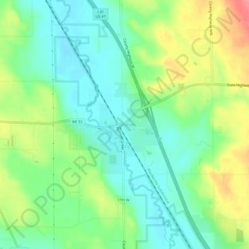
Nom : Carte topographique Allenton, altitude, relief.
Lieu : Allenton, Washington County, Wisconsin, 53002, United States (43.40105 -88.36087 43.44105 -88.32087)
Altitude moyenne : 313 m
Altitude minimum : 284 m
Altitude maximum : 363 m
Faire un don
Équipez-vous pour votre prochaine aventure :
En tant que Partenaire Amazon, ce site perçoit une commission sur les achats éligibles sans surcoût pour vous.
Autres cartes topographiques
Cliquez sur une carte pour visualiser sa topographie, son altitude et son relief.
West Bend
United States > Wisconsin > Washington County
West Bend is in the Kettle Moraine region, and its topography is varied. The glacial activity has formed many kettles and hills throughout the region.
Altitude moyenne : 298 m
Village of Richfield
United States > Wisconsin > Washington County
According to the United States Census Bureau, the village has a total area of 36.46 square miles (94.43 km2), of which, 35.91 square miles (93.01 km2) of it is land and 0.55 square miles (1.42 km2) is water. The low point in the village lies in Section 1 at Little Cedar Creek with an elevation of 856 feet. The…
Altitude moyenne : 296 m
Faire un don
Équipez-vous pour votre prochaine aventure :
En tant que Partenaire Amazon, ce site perçoit une commission sur les achats éligibles sans surcoût pour vous.
Faire un don
Équipez-vous pour votre prochaine aventure :
En tant que Partenaire Amazon, ce site perçoit une commission sur les achats éligibles sans surcoût pour vous.
West Bend
United States > Wisconsin > Washington County
West Bend is in the Kettle Moraine region, and its topography is varied. The glacial activity has formed many kettles and hills throughout the region.
Altitude moyenne : 298 m
West Bend
United States > Wisconsin > Washington County
West Bend is in the Kettle Moraine region, and its topography is varied. The glacial activity has formed many kettles and hills throughout the region.
Altitude moyenne : 298 m
Faire un don
Équipez-vous pour votre prochaine aventure :
En tant que Partenaire Amazon, ce site perçoit une commission sur les achats éligibles sans surcoût pour vous.