
Faire un don
Équipez-vous pour votre prochaine aventure :
En tant que Partenaire Amazon, ce site perçoit une commission sur les achats éligibles sans surcoût pour vous.
Carte topographique Batchworth Heath
Cliquez sur la carte pour afficher l’altitude.
Faire un don
Équipez-vous pour votre prochaine aventure :
En tant que Partenaire Amazon, ce site perçoit une commission sur les achats éligibles sans surcoût pour vous.
À propos de cette carte
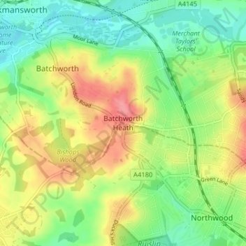
Nom : Carte topographique Batchworth Heath, altitude, relief.
Altitude moyenne : 76 m
Altitude minimum : 42 m
Altitude maximum : 121 m
Faire un don
Équipez-vous pour votre prochaine aventure :
En tant que Partenaire Amazon, ce site perçoit une commission sur les achats éligibles sans surcoût pour vous.
Autres cartes topographiques
Cliquez sur une carte pour visualiser sa topographie, son altitude et son relief.
Croxley Green
United Kingdom > England > Hertfordshire > Three Rivers > Rickmansworth
Altitude moyenne : 67 m
The Rookery
United Kingdom > England > Hertfordshire > Three Rivers > Abbots Langley > Langleybury
Altitude moyenne : 92 m
Faire un don
Équipez-vous pour votre prochaine aventure :
En tant que Partenaire Amazon, ce site perçoit une commission sur les achats éligibles sans surcoût pour vous.
Oxhey Woods Local Nature Reserve
United Kingdom > England > Hertfordshire > Three Rivers > South Oxhey
Altitude moyenne : 88 m