
Faire un don
Équipez-vous pour votre prochaine aventure :
En tant que Partenaire Amazon, ce site perçoit une commission sur les achats éligibles sans surcoût pour vous.
Carte topographique Duanesburg
Cliquez sur la carte pour afficher l’altitude.
Faire un don
Équipez-vous pour votre prochaine aventure :
En tant que Partenaire Amazon, ce site perçoit une commission sur les achats éligibles sans surcoût pour vous.
Duanesburg
The town consists of mostly wooded hills up to an elevation of approximately 1,400 feet (430 m) above sea level. Most of the town was cleared farmland until the late 20th century. After this point forests grew to cover 60% of the total land area with a canopy higher than 40 feet (12 m). The forest is primary composed of poplar, hemlock, oak, maple, white pine, and balsam fir. The maximum tree heights in Duanesburg are approximately 80 feet (24 m) high.
Faire un don
Équipez-vous pour votre prochaine aventure :
En tant que Partenaire Amazon, ce site perçoit une commission sur les achats éligibles sans surcoût pour vous.
À propos de cette carte
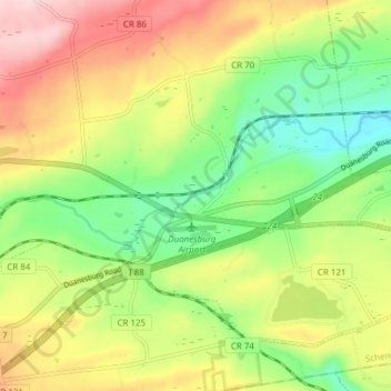
Nom : Carte topographique Duanesburg, altitude, relief.
Altitude moyenne : 267 m
Altitude minimum : 154 m
Altitude maximum : 410 m
Faire un don
Équipez-vous pour votre prochaine aventure :
En tant que Partenaire Amazon, ce site perçoit une commission sur les achats éligibles sans surcoût pour vous.