
Carte topographique Robie Creek
Carte interactive
Cliquez sur la carte pour afficher l’altitude.
À propos de cette carte
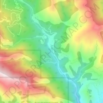
Nom : Carte topographique Robie Creek, altitude, relief.
Lieu : Robie Creek, Boise County, Idaho, United States of America (43.64933 -116.02892 43.65829 -116.02425)
Altitude moyenne : 1 264 m
Altitude minimum : 1 028 m
Altitude maximum : 1 566 m
Autres cartes topographiques
Cliquez sur une carte pour visualiser sa topographie, son altitude et son relief.
Basalt
United States of America > Idaho > Basalt
Basalt, Bingham County, Idaho, 83218, United States of America
Altitude moyenne : 1 398 m
Horse Ranch Mountain
United States of America > Idaho
Horse Ranch Mountain, Elmore County, Idaho, United States of America
Altitude moyenne : 1 843 m
Coeur d'Alene River
United States of America > Idaho
Coeur d'Alene River, Kootenai County, Idaho, United States of America
Altitude moyenne : 707 m
Nordman
United States of America > Idaho
Nordman, Bonner County, Idaho, 83848, United States of America
Altitude moyenne : 831 m
Vernon Lake
United States of America > Idaho
Vernon Lake, Trail 482, Boise County, Idaho, United States of America
Altitude moyenne : 2 686 m
Featherville
United States of America > Idaho > Featherville
Featherville, Elmore County, Idaho, United States of America
Altitude moyenne : 1 513 m
Kendrick
United States of America > Idaho > Kendrick
Kendrick, Latah County, Idaho, 83537, United States of America
Altitude moyenne : 559 m
Blackmare Lake
United States of America > Idaho
Blackmare Lake, Needles Route Pack Trail, Valley County, Idaho, United States of America
Altitude moyenne : 2 298 m