Géolocaliser

Carte topographique Sturry

Cliquez sur la carte pour afficher l’altitude.

À propos de cette carte

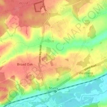
Nom : Carte topographique Sturry, altitude, relief.

Lieu : Sturry, Canterbury, Kent, England, United Kingdom (51.29568 1.08458 51.33499 1.14726)

Altitude moyenne : 32 m

Altitude minimum : -2 m

Altitude maximum : 58 m

👉 Easily get elevation data in JSON, GeoTIFF and KML formats using Elevation API
Merci de soutenir ce site ❤️
Faire un don

Équipez-vous pour votre prochaine aventure :

En tant que Partenaire Amazon, ce site perçoit une commission sur les achats éligibles sans surcoût pour vous.

Autres cartes topographiques

Cliquez sur une carte pour visualiser sa topographie, son altitude et son relief.

Hillborough

United Kingdom > England > Kent > Canterbury

Altitude moyenne : 15 m

Broomfield

United Kingdom > England > Kent > Canterbury

Altitude moyenne : 25 m

Blean

United Kingdom > England > Kent > Canterbury

Altitude moyenne : 66 m

Tankerton

United Kingdom > England > Kent > Canterbury

Altitude moyenne : 8 m

Reculver

United Kingdom > England > Kent > Canterbury

Altitude moyenne : 5 m

Clapham Hill

United Kingdom > England > Kent > Canterbury > Seasalter

Altitude moyenne : 29 m

Swalecliffe

United Kingdom > England > Kent > Canterbury

Altitude moyenne : 8 m

Pean Hill

United Kingdom > England > Kent > Canterbury

Altitude moyenne : 52 m

Stodmarsh

United Kingdom > England > Kent > Canterbury > Wickhambreaux

Altitude moyenne : 12 m

Herne

United Kingdom > England > Kent > Canterbury

Altitude moyenne : 30 m

Rough Common

United Kingdom > England > Kent > Canterbury

Altitude moyenne : 55 m

Broad Oak

United Kingdom > England > Kent > Canterbury

Altitude moyenne : 36 m

Harbledown

United Kingdom > England > Kent > Canterbury

Altitude moyenne : 41 m

Seasalter

United Kingdom > England > Kent > Canterbury

Altitude moyenne : 12 m

Upper Harbledown

United Kingdom > England > Kent > Canterbury

Altitude moyenne : 60 m

Ickham

United Kingdom > England > Kent > Canterbury

Altitude moyenne : 18 m

Denstroude

United Kingdom > England > Kent > Canterbury

Altitude moyenne : 54 m

Lower Hardres

United Kingdom > England > Kent > Canterbury

Altitude moyenne : 86 m

Maypole

United Kingdom > England > Kent > Canterbury > Hoath > Maypole

Altitude moyenne : 26 m

Honey Hill

United Kingdom > England > Kent > Canterbury > Blean

Altitude moyenne : 61 m

Tyler Hill

United Kingdom > England > Kent > Canterbury

Altitude moyenne : 56 m

Marshside

United Kingdom > England > Kent > Canterbury > Marshside

Altitude moyenne : 13 m

Anvil Green

United Kingdom > England > Kent > Canterbury > Waltham

Altitude moyenne : 119 m

Breach

United Kingdom > England > Kent > Canterbury > Barham

Altitude moyenne : 105 m

Tankerton

United Kingdom > England > Kent > Canterbury

Altitude moyenne : 8 m

Harbledown

United Kingdom > England > Kent > Canterbury

Altitude moyenne : 41 m

Harbledown

United Kingdom > England > Kent > Canterbury

Altitude moyenne : 41 m

Reculver

United Kingdom > England > Kent > Canterbury

Altitude moyenne : 5 m

Équipez-vous pour votre prochaine aventure :

🧥Vestes softshell - Vestes respirantes coupe-vent
🍴Couverts de Voyage - Set de couverts compacts et durables en titane ou inox.
🧭Boussoles d’orientation - Instruments fiables pour lecture de cartes et navigation terrestre
🌡️Couverture de Survie - Équipement de sécurité obligatoire en fond de sac.
🌂Parapluie de Marche - Alternative à la veste pour rester au sec sans transpirer.

En tant que Partenaire Amazon, ce site perçoit une commission sur les achats éligibles sans surcoût pour vous.