
Faire un don
Équipez-vous pour votre prochaine aventure :
En tant que Partenaire Amazon, ce site perçoit une commission sur les achats éligibles sans surcoût pour vous.
Carte topographique Central Point
Cliquez sur la carte pour afficher l’altitude.
Faire un don
Équipez-vous pour votre prochaine aventure :
En tant que Partenaire Amazon, ce site perçoit une commission sur les achats éligibles sans surcoût pour vous.
Central Point
The city lies at an elevation of about 1,272 feet (388 m) along Oregon Highway 99 and Interstate 5 northwest of Medford. Jacksonville is to the south and Gold Hill to the northwest. The Central Oregon and Pacific Railroad passes through Central Point.
Faire un don
Équipez-vous pour votre prochaine aventure :
En tant que Partenaire Amazon, ce site perçoit une commission sur les achats éligibles sans surcoût pour vous.
À propos de cette carte
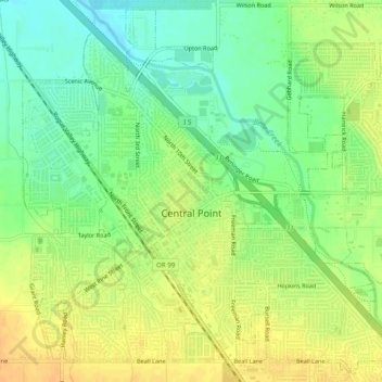
Nom : Carte topographique Central Point, altitude, relief.
Altitude moyenne : 385 m
Altitude minimum : 368 m
Altitude maximum : 401 m
Faire un don
Équipez-vous pour votre prochaine aventure :
En tant que Partenaire Amazon, ce site perçoit une commission sur les achats éligibles sans surcoût pour vous.
Autres cartes topographiques
Cliquez sur une carte pour visualiser sa topographie, son altitude et son relief.
Lost Creek Lake
United States > Oregon > Jackson County
The primary purpose of the dam is flood control and is operated in conjunction with Applegate Dam to regulate water flows down the river as well as to impound water for summer use. The dam is an earthfill structure with a gated spillway and contains two hydroelectric generating units with a total capacity of…
Altitude moyenne : 729 m
Faire un don
Équipez-vous pour votre prochaine aventure :
En tant que Partenaire Amazon, ce site perçoit une commission sur les achats éligibles sans surcoût pour vous.
Siskiyou Gap
United States > Oregon > Jackson County
"The original pass crosses the divide between the Rogue and Klamath Rivers at a slight topographic notch formed by the geological contact between the older Siskiyou Mountains to the west and the younger volcanic Cascade Range to the east." (Jeffrey M. LaLande, retired, forest archaeologist, Rogue…
Altitude moyenne : 1 746 m