
Carte topographique Salt Lake City
Carte interactive
Cliquez sur la carte pour afficher l’altitude.
À propos de cette carte
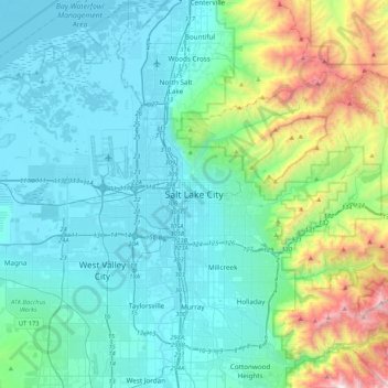
Nom : Carte topographique Salt Lake City, altitude, relief.
Altitude moyenne : 1 625 m
Altitude minimum : 1 278 m
Altitude maximum : 3 231 m
Salt Lake City has an area of 110.4 square miles (286 km2) and an average elevation of 4,327 feet (1,319 m) above sea level. The lowest point within the boundaries of the city is 4,210 feet (1,280 m) near the Jordan River and the Great Salt Lake, and the highest is Grandview Peak, at 9,410 feet (2,868 m).
Autres cartes topographiques
Cliquez sur une carte pour visualiser sa topographie, son altitude et son relief.
Grandview Peak
United States > Utah > Salt Lake County > Salt Lake City
Grandview Peak, Salt Lake City, Salt Lake County, Utah, United States
Altitude moyenne : 2 533 m