
Carte topographique Place Fell
Cliquez sur la carte pour afficher l’altitude.
Place Fell
Place Fell can be climbed from Patterdale, either via Boredale Hause or more directly by aiming up the face between Bleaberry Knott and The Knight. Ascents can also be made from Sandwick up either of the north eastern ridges, or from Boredale via the Hause. The altitude gain from the shores of Ullswater to the peak of Place Fell is 512 m (1,680 ft), but trails have shallow gradients and no hands-on scrambling is required; scrambling opportunities are few, even off-trail.
À propos de cette carte
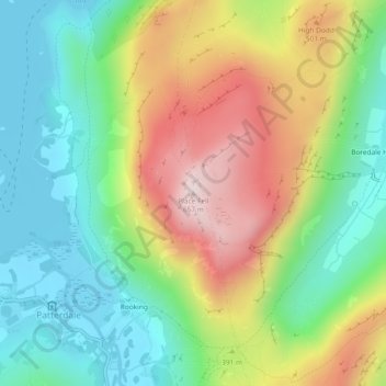
Nom : Carte topographique Place Fell, altitude, relief.
Altitude moyenne : 341 m
Altitude minimum : 145 m
Altitude maximum : 653 m
Autres cartes topographiques
Cliquez sur une carte pour visualiser sa topographie, son altitude et son relief.
Brown Cove Tarn
United Kingdom > England > Westmorland and Furness > Patterdale
Altitude moyenne : 699 m
Brothers Water
United Kingdom > England > Westmorland and Furness > Patterdale > Hartsop
Altitude moyenne : 298 m