
Faire un don
Équipez-vous pour votre prochaine aventure :
En tant que Partenaire Amazon, ce site perçoit une commission sur les achats éligibles sans surcoût pour vous.
Carte topographique Șindrești
Cliquez sur la carte pour afficher l’altitude.
Faire un don
Équipez-vous pour votre prochaine aventure :
En tant que Partenaire Amazon, ce site perçoit une commission sur les achats éligibles sans surcoût pour vous.
À propos de cette carte
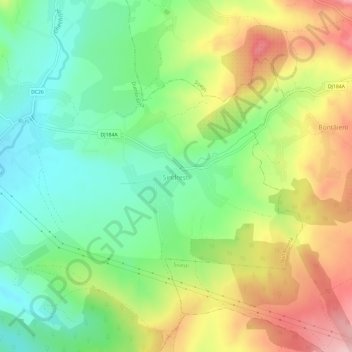
Nom : Carte topographique Șindrești, altitude, relief.
Lieu : Șindrești, Maramureș, 437149, Romania (47.58660 23.67513 47.62660 23.71513)
Altitude moyenne : 282 m
Altitude minimum : 207 m
Altitude maximum : 389 m
Faire un don
Équipez-vous pour votre prochaine aventure :
En tant que Partenaire Amazon, ce site perçoit une commission sur les achats éligibles sans surcoût pour vous.
Autres cartes topographiques
Cliquez sur une carte pour visualiser sa topographie, son altitude et son relief.
Baia Mare
The city is situated in the vicinity of the Gutâi and Igniș Mountains. Altitudes reach 1400 meters in some peaks. The area is famous for its outstanding landscapes, and the mountains are easily accessible from the city, famous routes being: Igniș (1307 m), Mogoșa (1246 m), Gutâi (1443 m), Creasta…
Altitude moyenne : 592 m
Faire un don
Équipez-vous pour votre prochaine aventure :
En tant que Partenaire Amazon, ce site perçoit une commission sur les achats éligibles sans surcoût pour vous.
Baia Mare
The city is situated in the vicinity of the Gutâi and Igniș [ro] mountains. Altitudes reach 1,400 metres (4,600 feet) in some peaks. The area is famous for its outstanding landscapes, and the mountains are easily accessible from the city, notable routes being: Igniș (1,307 m), Mogoșa (1,246 m), Gutâi…
Altitude moyenne : 592 m
Faire un don
Équipez-vous pour votre prochaine aventure :
En tant que Partenaire Amazon, ce site perçoit une commission sur les achats éligibles sans surcoût pour vous.
Baia Mare
The city is situated in the vicinity of the Gutâi and Igniș mountains. Altitudes reach 1,400 metres (4,600 feet) in some peaks. The area is famous for its outstanding landscapes, and the mountains are easily accessible from the city, notable routes being: Igniș (1,307 m), Mogoșa (1,246 m), Gutâi (1,443…
Altitude moyenne : 592 m
Faire un don
Équipez-vous pour votre prochaine aventure :
En tant que Partenaire Amazon, ce site perçoit une commission sur les achats éligibles sans surcoût pour vous.
Baia Mare
The city is situated in the vicinity of the Gutâi and Igniș Mountains. Altitudes reach 1400 meters in some peaks. The area is famous for its outstanding landscapes, and the mountains are easily accessible from the city, famous routes being: Igniș (1307 m), Mogoșa (1246 m), Gutâi (1443 m), Creasta…
Altitude moyenne : 592 m
Faire un don
Équipez-vous pour votre prochaine aventure :
En tant que Partenaire Amazon, ce site perçoit une commission sur les achats éligibles sans surcoût pour vous.
Faire un don
Équipez-vous pour votre prochaine aventure :
En tant que Partenaire Amazon, ce site perçoit une commission sur les achats éligibles sans surcoût pour vous.
Faire un don
Équipez-vous pour votre prochaine aventure :
En tant que Partenaire Amazon, ce site perçoit une commission sur les achats éligibles sans surcoût pour vous.
Faire un don
Équipez-vous pour votre prochaine aventure :
En tant que Partenaire Amazon, ce site perçoit une commission sur les achats éligibles sans surcoût pour vous.
Faire un don
Équipez-vous pour votre prochaine aventure :
En tant que Partenaire Amazon, ce site perçoit une commission sur les achats éligibles sans surcoût pour vous.
Vișeu de Sus
Vișeu de Sus is located in the northeastern part of Maramureș County, on the border with Ukraine. The town lies at the confluence of the rivers Vișeu and Vaser, at an altitude of 427 m (1,401 ft) above sea level, having the characteristics of a mountain city. It neighbors the communes of Moisei to the…
Altitude moyenne : 865 m