
Carte topographique Crowhurst Nature Reserve
Carte interactive
Cliquez sur la carte pour afficher l’altitude.
À propos de cette carte
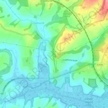
Nom : Carte topographique Crowhurst Nature Reserve, altitude, relief.
Altitude moyenne : 26 m
Altitude minimum : -2 m
Altitude maximum : 98 m
Autres cartes topographiques
Cliquez sur une carte pour visualiser sa topographie, son altitude et son relief.
Senlac Hill
United Kingdom > England > Rother
Senlac Hill, Rother, East Sussex, South East, England, TN33 0AD, United Kingdom
Altitude moyenne : 62 m
Quickbourne
United Kingdom > England > Rother > Northiam > Quickbourne
Quickbourne, Northiam, Rother, East Sussex, South East England, England, TN31 6QX, United Kingdom
Altitude moyenne : 23 m