
Faire un don
Équipez-vous pour votre prochaine aventure :
En tant que Partenaire Amazon, ce site perçoit une commission sur les achats éligibles sans surcoût pour vous.
Carte topographique Hudson
Cliquez sur la carte pour afficher l’altitude.
Faire un don
Équipez-vous pour votre prochaine aventure :
En tant que Partenaire Amazon, ce site perçoit une commission sur les achats éligibles sans surcoût pour vous.
Hudson
Hudson features a predominantly flat and low-lying topography typical of the region, with an average elevation of approximately 16 feet above sea level. This terrain is interspersed with various wetlands and small lakes, creating a rich ecosystem that supports diverse wildlife. The area also includes a few gently rolling hills, but overall, the landscape is characterized by its proximity to the Gulf of Mexico, leading to sandy soils and coastal marshes. The nearby coastal environment contributes to the scenic beauty of Hudson, making it an appealing location for recreational activities like fishing and boating.
Faire un don
Équipez-vous pour votre prochaine aventure :
En tant que Partenaire Amazon, ce site perçoit une commission sur les achats éligibles sans surcoût pour vous.
À propos de cette carte
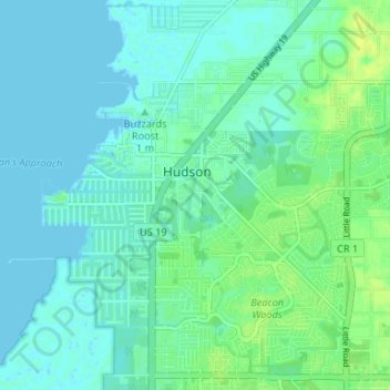
Nom : Carte topographique Hudson, altitude, relief.
Lieu : Hudson, Pasco County, Florida, 34667, United States (28.33816 -82.72364 28.37833 -82.65768)
Altitude moyenne : 5 m
Altitude minimum : -1 m
Altitude maximum : 15 m
Faire un don
Équipez-vous pour votre prochaine aventure :
En tant que Partenaire Amazon, ce site perçoit une commission sur les achats éligibles sans surcoût pour vous.