
Carte topographique City of Lockport
Carte interactive
Cliquez sur la carte pour afficher l’altitude.
À propos de cette carte
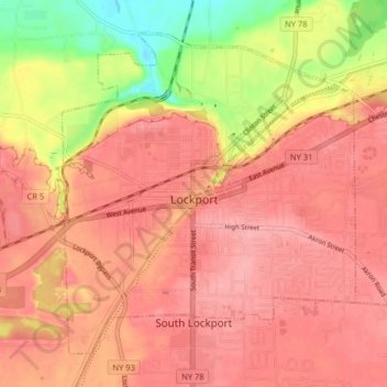
Nom : Carte topographique City of Lockport, altitude, relief.
Altitude moyenne : 174 m
Altitude minimum : 106 m
Altitude maximum : 203 m
Lockport is at the junction of several major truck routes, including NY Route 78 (Transit Road), NY Route 31, NY Route 77 and NY Route 93. It is 17 miles north of Interstate 90 via NY Route 78. The highest point is the bell tower at 452 High Street, with the street itself being the highest street as measured by frontage above the 650 feet elevation.
Autres cartes topographiques
Cliquez sur une carte pour visualiser sa topographie, son altitude et son relief.
Town of Lewiston
United States > New York > Niagara County
Town of Lewiston, Niagara County, New York, United States
Altitude moyenne : 134 m
Ransomville
United States > New York > Niagara County
Ransomville, Town of Porter, Niagara County, New York, 14131, United States
Altitude moyenne : 97 m
Sanborn
United States > New York > Niagara County
Sanborn, Town of Cambria, Niagara County, New York, 14132, United States
Altitude moyenne : 193 m
332
United States > New York > Niagara County > City of Niagara Falls
332, City of Niagara Falls, Niagara County, New York, United States, Niagara Falls State Park
Altitude moyenne : 169 m
Lockport
United States > New York > Niagara County
Lockport, City of Lockport, Niagara County, New York, 14094, United States
Altitude moyenne : 152 m
Town of Wheatfield
United States > New York > Niagara County
Town of Wheatfield, Niagara County, New York, United States
Altitude moyenne : 180 m
Village of Lewiston
United States > New York > Niagara County
Village of Lewiston, Town of Lewiston, Niagara County, New York, United States
Altitude moyenne : 122 m
Village of Middleport
United States > New York > Niagara County
Village of Middleport, Town of Royalton, Niagara County, New York, United States
Altitude moyenne : 156 m
South Lockport
United States > New York > Niagara County
South Lockport, Town of Lockport, Niagara County, New York, United States
Altitude moyenne : 185 m
City of North Tonawanda
United States > New York > Niagara County
City of North Tonawanda, Niagara County, New York, 14120, United States
Altitude moyenne : 177 m
City of Niagara Falls
United States > New York > Niagara County
City of Niagara Falls, Niagara County, New York, United States
Altitude moyenne : 180 m
Village of Wilson
United States > New York > Niagara County
Village of Wilson, Town of Wilson, Niagara County, New York, United States
Altitude moyenne : 84 m
Love Canal
United States > New York > Niagara County > Niagara Falls > Black Creek Village
Love Canal, Love Canal superfund site, Black Creek Village, Niagara Falls, Niagara County, New York, 14304, United States
Altitude moyenne : 176 m
Escarpment
United States > New York > Niagara County > Town of Lewiston > Escarpment
Escarpment, Town of Lewiston, Niagara County, New York, 14092, United States
Altitude moyenne : 156 m
La Salle
United States > New York > Niagara County > Niagara Falls > La Salle
La Salle, Niagara Falls, Niagara County, New York, 14304, United States
Altitude moyenne : 176 m
Rapids
United States > New York > Niagara County > Rapids
Rapids, Town of Lockport, Niagara County, New York, United States
Altitude moyenne : 179 m
Artpark State Park
United States > New York > Niagara County > Lewiston > Lewiston Heights
Artpark State Park, Lewiston Heights, Lewiston, Niagara County, New York, United States
Altitude moyenne : 154 m
Olcott
United States > New York > Niagara County
Olcott, Town of Newfane, Niagara County, New York, United States
Altitude moyenne : 88 m
Village of Youngstown
United States > New York > Niagara County
Village of Youngstown, Town of Porter, Niagara County, New York, United States
Altitude moyenne : 86 m