
Faire un don
Équipez-vous pour votre prochaine aventure :
En tant que Partenaire Amazon, ce site perçoit une commission sur les achats éligibles sans surcoût pour vous.
Carte topographique Konaklı
Cliquez sur la carte pour afficher l’altitude.
Faire un don
Équipez-vous pour votre prochaine aventure :
En tant que Partenaire Amazon, ce site perçoit une commission sur les achats éligibles sans surcoût pour vous.
Konaklı
Misthi or Misti, was a Greek city in the region of Cappadocia, in what is now Turkey. It was situated 82 kilometres southwest of the regional capital of Caesarea (Greek: Καισαρεία), nowadays Kayseri, Turkey, and belonged administratively to the nearby city of Nigde, 26 kilometres north-northwest and at an altitude of 1380 metres above sea level.
Faire un don
Équipez-vous pour votre prochaine aventure :
En tant que Partenaire Amazon, ce site perçoit une commission sur les achats éligibles sans surcoût pour vous.
À propos de cette carte
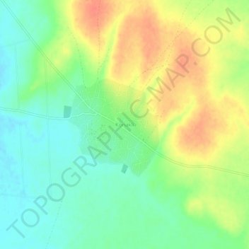
Nom : Carte topographique Konaklı, altitude, relief.
Lieu : Konaklı, Niğde, Central Anatolia Region, Turkey (38.15176 34.82921 38.19176 34.86921)
Altitude moyenne : 1 352 m
Altitude minimum : 1 330 m
Altitude maximum : 1 379 m
Faire un don
Équipez-vous pour votre prochaine aventure :
En tant que Partenaire Amazon, ce site perçoit une commission sur les achats éligibles sans surcoût pour vous.
Autres cartes topographiques
Cliquez sur une carte pour visualiser sa topographie, son altitude et son relief.
Lake Van
Lake Van (Turkish: Van Gölü; Armenian: Վանա լիճ, romanized: Vana lič̣; Kurdish: Gola Wanê) is the largest lake in Turkey.[3][4] It lies in the far east of Turkey, in the provinces of Van and Bitlis in the Armenian highlands. It is a saline soda lake, receiving water from many small streams that…
Altitude moyenne : 1 902 m
Faire un don
Équipez-vous pour votre prochaine aventure :
En tant que Partenaire Amazon, ce site perçoit une commission sur les achats éligibles sans surcoût pour vous.
Anatolia
Anatolia (Turkish: Anadolu), also known as Asia Minor, is a peninsula in West Asia that makes up the majority of the land area of Turkey. It is the westernmost protrusion of Asia and is geographically bounded by the Mediterranean Sea to the south, the Aegean Sea to the west, the Turkish Straits to the…
Altitude moyenne : 518 m
Faire un don
Équipez-vous pour votre prochaine aventure :
En tant que Partenaire Amazon, ce site perçoit une commission sur les achats éligibles sans surcoût pour vous.
Faire un don
Équipez-vous pour votre prochaine aventure :
En tant que Partenaire Amazon, ce site perçoit une commission sur les achats éligibles sans surcoût pour vous.
Adana
Aladağlar National Park, located north of Adana, is a huge park of around 55,000 hectares, the summit of Demirkazik at 3756m is the highest point in the middle Taurus mountain range. There is a huge range of flora and fauna, and visitors may fish in the streams full of trout. Wildlife includes wild goats,…
Altitude moyenne : 879 m
Black Sea Region
The Black Sea region has a steep, rocky coast with rivers that cascade through the gorges of the coastal ranges. A few larger rivers, those cutting back through the Pontic Mountains (Doğu Karadeniz Dağları), have tributaries that flow in broad, elevated basins. Access inland from the coast is limited to a…
Altitude moyenne : 817 m
Faire un don
Équipez-vous pour votre prochaine aventure :
En tant que Partenaire Amazon, ce site perçoit une commission sur les achats éligibles sans surcoût pour vous.
Kızılcahamam
Kızılcahamam is a town and district of Ankara Province in the Central Anatolia region of Turkey, 70 km north of the city of Ankara, near the motorway to Istanbul. According to 2010 census, population of the district is 25,203 of which 16,726 live in the town of Kızılcahamam. The district covers an area of…
Altitude moyenne : 1 367 m
Faire un don
Équipez-vous pour votre prochaine aventure :
En tant que Partenaire Amazon, ce site perçoit une commission sur les achats éligibles sans surcoût pour vous.
Çivril
Çivril district area is notable by the large size within its boundaries of Lake Işıklı, a freshwater lake which is a fishing reserve and recreational are for its region, aside from being one of the sources of Büyük Menderes River. The lake lies at an altitude of 821 m and its area is 73 square…
Altitude moyenne : 996 m
Faire un don
Équipez-vous pour votre prochaine aventure :
En tant que Partenaire Amazon, ce site perçoit une commission sur les achats éligibles sans surcoût pour vous.
Faire un don
Équipez-vous pour votre prochaine aventure :
En tant que Partenaire Amazon, ce site perçoit une commission sur les achats éligibles sans surcoût pour vous.
Nur Mountains
The range is around 100 miles (200 kilometers) in length and reaches a maximum elevation of 2,240 m (7,350 ft). It divides the coastal region of Cilicia from Antioch and inland Syria, making a natural border between Asia Minor (Anatolia) in the southeast region and the rest of Southwest Asia. Its highest peak…
Altitude moyenne : 365 m
Faire un don
Équipez-vous pour votre prochaine aventure :
En tant que Partenaire Amazon, ce site perçoit une commission sur les achats éligibles sans surcoût pour vous.
Asia Minor
Anatolia (Turkish: Anadolu), also known as Asia Minor, is a peninsula in West Asia that makes up the majority of the land area of Turkey. It is the westernmost protrusion of Asia and is geographically bounded by the Mediterranean Sea to the south, the Aegean Sea to the west, the Turkish Straits to the…
Altitude moyenne : 399 m
Dilek Peninsula National Park
Dilek Peninsula-Büyük Menderes Delta National Park has a Mediterranean climate (Köppen climate classification Csa), and as such, it is dry and mild throughout most of the year, except during the winters, when most of the yearly precipitation occurs. The average temperature year-round is about 18 °C (64…
Altitude moyenne : 100 m
Faire un don
Équipez-vous pour votre prochaine aventure :
En tant que Partenaire Amazon, ce site perçoit une commission sur les achats éligibles sans surcoût pour vous.
Ortaköy
Ortaköy is a town in Aksaray Province in the Central Anatolia region of Turkey, located north of the city of Aksaray. It is the seat of Ortaköy District. Its population is 20,511 (2021). Its average elevation is 1,140 m (3,740 ft). The town consists of 12 quarters, including Balcı.
Altitude moyenne : 1 159 m
Faire un don
Équipez-vous pour votre prochaine aventure :
En tant que Partenaire Amazon, ce site perçoit une commission sur les achats éligibles sans surcoût pour vous.
Faire un don
Équipez-vous pour votre prochaine aventure :
En tant que Partenaire Amazon, ce site perçoit une commission sur les achats éligibles sans surcoût pour vous.
Faire un don
Équipez-vous pour votre prochaine aventure :
En tant que Partenaire Amazon, ce site perçoit une commission sur les achats éligibles sans surcoût pour vous.
Suluova
Suluova is a town in Amasya Province of Turkey, located on high ground inland within the central Black Sea region. It is the seat of Suluova District. Its population is 39,286 (2021). Altitude is 510 m. The mayor is Fatih Üçok (AKP). Two-thirds of the district lies on the plain (watered by the Tersakan…
Altitude moyenne : 716 m
Faire un don
Équipez-vous pour votre prochaine aventure :
En tant que Partenaire Amazon, ce site perçoit une commission sur les achats éligibles sans surcoût pour vous.
Faire un don
Équipez-vous pour votre prochaine aventure :
En tant que Partenaire Amazon, ce site perçoit une commission sur les achats éligibles sans surcoût pour vous.
Faire un don
Équipez-vous pour votre prochaine aventure :
En tant que Partenaire Amazon, ce site perçoit une commission sur les achats éligibles sans surcoût pour vous.
Faire un don
Équipez-vous pour votre prochaine aventure :
En tant que Partenaire Amazon, ce site perçoit une commission sur les achats éligibles sans surcoût pour vous.
Çaldıran
At 2,045 m (6,709 ft) above sea level, Çaldıran has a humid continental climate, with Mediterranean influences (Dsb, according to the Köppen climate classification). Summers are mild and dry and winters are cold and snowy, with very low temperatures, due to its elevation. The lowest temperature recorded in…
Altitude moyenne : 2 325 m
Faire un don
Équipez-vous pour votre prochaine aventure :
En tant que Partenaire Amazon, ce site perçoit une commission sur les achats éligibles sans surcoût pour vous.
Faire un don
Équipez-vous pour votre prochaine aventure :
En tant que Partenaire Amazon, ce site perçoit une commission sur les achats éligibles sans surcoût pour vous.
Faire un don
Équipez-vous pour votre prochaine aventure :
En tant que Partenaire Amazon, ce site perçoit une commission sur les achats éligibles sans surcoût pour vous.
Faire un don
Équipez-vous pour votre prochaine aventure :
En tant que Partenaire Amazon, ce site perçoit une commission sur les achats éligibles sans surcoût pour vous.
Faire un don
Équipez-vous pour votre prochaine aventure :
En tant que Partenaire Amazon, ce site perçoit une commission sur les achats éligibles sans surcoût pour vous.
Faire un don
Équipez-vous pour votre prochaine aventure :
En tant que Partenaire Amazon, ce site perçoit une commission sur les achats éligibles sans surcoût pour vous.
Faire un don
Équipez-vous pour votre prochaine aventure :
En tant que Partenaire Amazon, ce site perçoit une commission sur les achats éligibles sans surcoût pour vous.
Faire un don
Équipez-vous pour votre prochaine aventure :
En tant que Partenaire Amazon, ce site perçoit une commission sur les achats éligibles sans surcoût pour vous.
Keban Dam
The Keban Dam is a combined rockfill and concrete gravity hydroelectric dam operated by the State Hydraulic Works (DSİ). The dam is 1,097 metres (3,599 ft) long and its crest is 207 metres (679 ft) above the level of the river-bed (848 metres (2,782 ft) above sea-level). Its eight water turbines are capable…
Altitude moyenne : 844 m
Faire un don
Équipez-vous pour votre prochaine aventure :
En tant que Partenaire Amazon, ce site perçoit une commission sur les achats éligibles sans surcoût pour vous.