
Faire un don
Équipez-vous pour votre prochaine aventure :
En tant que Partenaire Amazon, ce site perçoit une commission sur les achats éligibles sans surcoût pour vous.
Carte topographique Puerto Williams
Cliquez sur la carte pour afficher l’altitude.
Faire un don
Équipez-vous pour votre prochaine aventure :
En tant que Partenaire Amazon, ce site perçoit une commission sur les achats éligibles sans surcoût pour vous.
Puerto Williams
The climate of Puerto Williams is a temperate subpolar oceanic climate (Cfc) bordering closely on a tundra climate (ET) according to the Köppen climate classification. The summers are short and cool while the winters are long, wet, but moderate. Rainfall is around 512.3 mm (20 in) a year and temperatures are steady throughout the year. Snowfall can occur in summer. The cold and wet summers help preserve glaciers. Although the area around the town is well-forested, exposed areas at some distance from or altitude above it have a sub-Antarctic climate typical of tundra, which makes the growth of trees impossible.
Faire un don
Équipez-vous pour votre prochaine aventure :
En tant que Partenaire Amazon, ce site perçoit une commission sur les achats éligibles sans surcoût pour vous.
À propos de cette carte
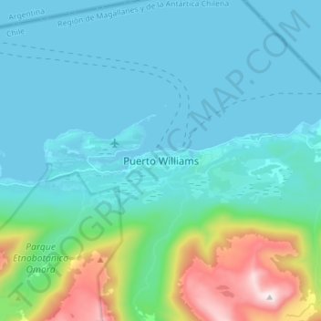
Nom : Carte topographique Puerto Williams, altitude, relief.
Altitude moyenne : 151 m
Altitude minimum : 0 m
Altitude maximum : 898 m
Faire un don
Équipez-vous pour votre prochaine aventure :
En tant que Partenaire Amazon, ce site perçoit une commission sur les achats éligibles sans surcoût pour vous.
Autres cartes topographiques
Cliquez sur une carte pour visualiser sa topographie, son altitude et son relief.
Isla Dumont D’Urville
Chile > Magallanes and Chilean Antarctica Region > Provincia de la Antártica Chilena > Cape Horn
Altitude moyenne : 53 m