
Carte topographique Kalapet
Carte interactive
Cliquez sur la carte pour afficher l’altitude.
À propos de cette carte
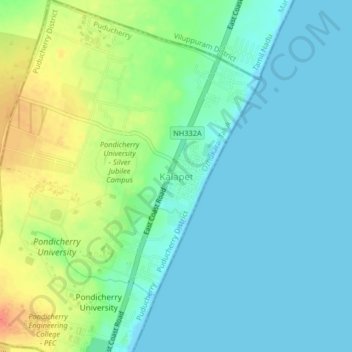
Nom : Carte topographique Kalapet, altitude, relief.
Altitude moyenne : 14 m
Altitude minimum : -1 m
Altitude maximum : 45 m
Autres cartes topographiques
Cliquez sur une carte pour visualiser sa topographie, son altitude et son relief.
moolakulam
India > Puducherry > Ozhukarai Taluk > Oulgaret
moolakulam, Mettupalayam, Oulgaret, Ozhukarai Taluk, Puducherry district, Puducherry, 605010, India
Altitude moyenne : 12 m
Oulgaret
India > Puducherry > Ozhukarai Taluk
Oulgaret, Ozhukarai Taluk, Puducherry District, Puducherry, 605005, India
Altitude moyenne : 18 m