
Faire un don
Équipez-vous pour votre prochaine aventure :
En tant que Partenaire Amazon, ce site perçoit une commission sur les achats éligibles sans surcoût pour vous.
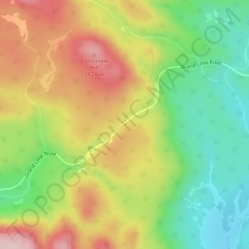
Carte topographique Isa Lake
Cliquez sur la carte pour afficher l’altitude.
Faire un don
Équipez-vous pour votre prochaine aventure :
En tant que Partenaire Amazon, ce site perçoit une commission sur les achats éligibles sans surcoût pour vous.
À propos de cette carte
Nom : Carte topographique Isa Lake, altitude, relief.
Lieu : Isa Lake, Teton County, Wyoming, United States (44.44021 -110.72040 44.44225 -110.71810)
Altitude moyenne : 2 504 m
Altitude minimum : 2 384 m
Altitude maximum : 2 640 m
Faire un don
Équipez-vous pour votre prochaine aventure :
En tant que Partenaire Amazon, ce site perçoit une commission sur les achats éligibles sans surcoût pour vous.
Autres cartes topographiques
Cliquez sur une carte pour visualiser sa topographie, son altitude et son relief.
Rocky Mountains
United States > Wyoming > Teton County
Agriculture and forestry are major industries. Agriculture includes dryland and irrigated farming and livestock grazing. Livestock are frequently moved between high-elevation summer pastures and low-elevation winter pastures, a practice known as transhumance.
Altitude moyenne : 2 292 m
Grand Teton National Park
United States > Wyoming > Teton County
Grand Teton National Park is named for Grand Teton, the tallest mountain in the Teton Range. The naming of the mountains is attributed to early 19th-century French-speaking trappers—les trois tétons (the three teats) was later anglicized and shortened to Tetons. At 13,775 feet (4,199 m), Grand Teton…
Altitude moyenne : 2 409 m
Jackson
United States > Wyoming > Teton County
Jackson is located at 43°28′31″N 110°46′9″W / 43.47528°N 110.76917°W / 43.47528; -110.76917 (43.475, −110.769), at an elevation of 6,237 feet (1,901 m) above sea level. According to the United States Census Bureau, the town has a total area of 2.95 square miles (7.64 km2), of which 2.91…
Altitude moyenne : 2 043 m
Buck Mountain
United States > Wyoming > Teton County
Buck Mountain (elevation: 11,943 feet (3,640 m)) is a mountain located in the Teton Range, Grand Teton National Park, Wyoming, immediately southeast of Grand Teton.
Altitude moyenne : 3 128 m
Faire un don
Équipez-vous pour votre prochaine aventure :
En tant que Partenaire Amazon, ce site perçoit une commission sur les achats éligibles sans surcoût pour vous.
Rocky Mountains
United States > Wyoming > Teton County
Agriculture and forestry are major industries. Agriculture includes dryland and irrigated farming and livestock grazing. Livestock are frequently moved between high-elevation summer pastures and low-elevation winter pastures, a practice known as transhumance.
Altitude moyenne : 2 292 m
Grand Teton National Park
United States > Wyoming > Teton County
Grand Teton National Park is named for Grand Teton, the tallest mountain in the Teton Range. The naming of the mountains is attributed to early 19th-century French-speaking trappers—les trois tétons (the three teats) was later anglicized and shortened to Tetons. At 13,775 feet (4,199 m), Grand Teton…
Altitude moyenne : 2 409 m
Faire un don
Équipez-vous pour votre prochaine aventure :
En tant que Partenaire Amazon, ce site perçoit une commission sur les achats éligibles sans surcoût pour vous.
Teton Range
United States > Wyoming > Teton County
One reason the Teton Range is famous is because of the dramatic elevation profile visible from the eastern side, which rises sharply from 4,000 to 7,000 feet (1,200–2,100 m) above the valley floor. Unlike most mountain ranges, the east side of the Teton Range lacks significant foothills or lower peaks which…
Altitude moyenne : 2 985 m
Faire un don
Équipez-vous pour votre prochaine aventure :
En tant que Partenaire Amazon, ce site perçoit une commission sur les achats éligibles sans surcoût pour vous.
Wilson
United States > Wyoming > Teton County > Wilson
Wilson is located at 43°29′11″N 110°52′45″W / 43.48639°N 110.87917°W / 43.48639; -110.87917 (43.4863, -110.8793). at an elevation of 6,148 feet (1,874 m) above sea level.
Altitude moyenne : 2 208 m
Faire un don
Équipez-vous pour votre prochaine aventure :
En tant que Partenaire Amazon, ce site perçoit une commission sur les achats éligibles sans surcoût pour vous.
Togwotee Pass
United States > Wyoming > Teton County
Togwotee Pass (pronounced TOH-guh-tee) is a high mountain pass in the western United States, at an elevation of 9,655 feet (2,943 m) above sea level. On the Continental Divide in the Absaroka Range of northwestern Wyoming in Teton County, it is between Dubois and Moran Junction in the Jackson Hole valley.
Altitude moyenne : 2 965 m
Rocky Mountains
United States > Wyoming > Teton County
Agriculture and forestry are major industries. Agriculture includes dryland and irrigated farming and livestock grazing. Livestock are frequently moved between high-elevation summer pastures and low-elevation winter pastures, a practice known as transhumance.
Altitude moyenne : 2 292 m
Faire un don
Équipez-vous pour votre prochaine aventure :
En tant que Partenaire Amazon, ce site perçoit une commission sur les achats éligibles sans surcoût pour vous.
Jackson
United States > Wyoming > Teton County
Jackson is located at an elevation of 6,237 feet (1,901 m) above sea level. According to the United States Census Bureau, the town has a total area of 3.009 square miles (7.79 km2), of which 2.978 square miles (7.71 km2) is land and 0.031 square miles (0.08 km2) (1.03%) is water.
Altitude moyenne : 2 043 m
Grand Teton National Park
United States > Wyoming > Teton County
Grand Teton National Park is named for Grand Teton, the tallest mountain in the Teton Range. At 13,775 feet (4,199 m), Grand Teton rises more than 7,000 feet (2,100 m) above Jackson Hole. The park has numerous lakes, including 15-mile-long (24 km) Jackson Lake as well as streams and the upper main stem of the…
Altitude moyenne : 2 409 m
Faire un don
Équipez-vous pour votre prochaine aventure :
En tant que Partenaire Amazon, ce site perçoit une commission sur les achats éligibles sans surcoût pour vous.
Buck Mountain
United States > Wyoming > Teton County
Buck Mountain (elevation: 11,943 feet (3,640 m)) is a mountain located in the Teton Range, Grand Teton National Park, Wyoming, immediately southeast of Grand Teton.
Altitude moyenne : 3 128 m
Faire un don
Équipez-vous pour votre prochaine aventure :
En tant que Partenaire Amazon, ce site perçoit une commission sur les achats éligibles sans surcoût pour vous.
Faire un don
Équipez-vous pour votre prochaine aventure :
En tant que Partenaire Amazon, ce site perçoit une commission sur les achats éligibles sans surcoût pour vous.
Jackson
United States > Wyoming > Teton County
Jackson is located at 43°28′31″N 110°46′9″W / 43.47528°N 110.76917°W / 43.47528; -110.76917 (43.475, −110.769), at an elevation of 6,237 feet (1,901 m) above sea level. According to the United States Census Bureau, the town has a total area of 2.95 square miles (7.64 km2), of which 2.91…
Altitude moyenne : 2 043 m
Faire un don
Équipez-vous pour votre prochaine aventure :
En tant que Partenaire Amazon, ce site perçoit une commission sur les achats éligibles sans surcoût pour vous.
Upper Geyser Basin
United States > Wyoming > Teton County > Upper Geyser Basin
Altitude moyenne : 2 295 m