
Faire un don
Équipez-vous pour votre prochaine aventure :
En tant que Partenaire Amazon, ce site perçoit une commission sur les achats éligibles sans surcoût pour vous.
Carte topographique Hoffman Notch Wilderness
Cliquez sur la carte pour afficher l’altitude.
Faire un don
Équipez-vous pour votre prochaine aventure :
En tant que Partenaire Amazon, ce site perçoit une commission sur les achats éligibles sans surcoût pour vous.
Hoffman Notch Wilderness
The forest cover ranges from second growth hardwoods of sapling and pole-size to nearly solid conifer stands of near mature size at the higher elevations. On some of the better soil, exceptionally large diameter hardwoods occur.
Faire un don
Équipez-vous pour votre prochaine aventure :
En tant que Partenaire Amazon, ce site perçoit une commission sur les achats éligibles sans surcoût pour vous.
À propos de cette carte
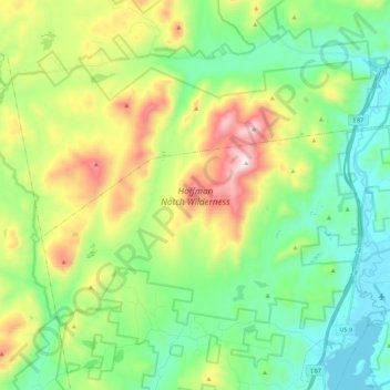
Nom : Carte topographique Hoffman Notch Wilderness, altitude, relief.
Altitude moyenne : 515 m
Altitude minimum : 242 m
Altitude maximum : 1 108 m
Faire un don
Équipez-vous pour votre prochaine aventure :
En tant que Partenaire Amazon, ce site perçoit une commission sur les achats éligibles sans surcoût pour vous.