
Carte topographique Kempsey
Cliquez sur la carte pour afficher l’altitude.
À propos de cette carte
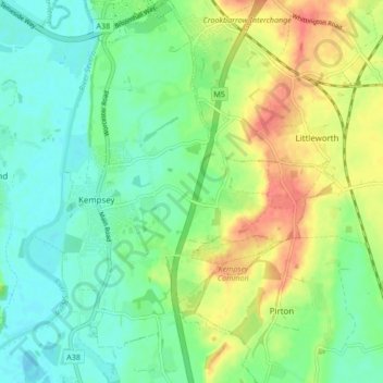
Nom : Carte topographique Kempsey, altitude, relief.
Altitude moyenne : 28 m
Altitude minimum : 9 m
Altitude maximum : 67 m
Autres cartes topographiques
Cliquez sur une carte pour visualiser sa topographie, son altitude et son relief.
Upper Broadheath
United Kingdom > England > Worcestershire > Malvern Hills > Crown East
Altitude moyenne : 44 m
Malvern
United Kingdom > England > Worcestershire > Malvern Hills
Malvern lies in the Lower Severn/Avon plain affording it a degree of shelter caused by virtue of its nestling in between the Cotswold hills to the east, the Welsh Hills and Mountains to the west, and Birmingham plateau to the north. Although as with all the British Isles it has a maritime climate, the local…
Altitude moyenne : 95 m
Kerswell Green
United Kingdom > England > Worcestershire > Malvern Hills > Kempsey
Altitude moyenne : 25 m
Corse Lawn
United Kingdom > England > Worcestershire > Malvern Hills > Eldersfield
Altitude moyenne : 26 m
The Hill, Abberley
United Kingdom > England > Worcestershire > Malvern Hills > Abberley
Altitude moyenne : 132 m
Elms Green
United Kingdom > England > Worcestershire > Malvern Hills > Abberley
Altitude moyenne : 121 m
Table Hill
United Kingdom > England > Worcestershire > Malvern Hills
Table Hill is situated in the range of Malvern Hills that runs about 13 kilometres (8 mi) north-south along the Herefordshire-Worcestershire border. It lies between North Hill and Sugarloaf Hill and has an elevation of 373 metres (1,224 ft).
Altitude moyenne : 188 m
Malvern
United Kingdom > England > Worcestershire > Malvern Hills
Malvern lies in the Lower Severn/Avon plain affording it a degree of shelter caused by virtue of its nestling in between the Cotswold hills to the east, the Welsh Hills and Mountains to the west, and Birmingham plateau to the north. Although as with all the British Isles it has a maritime climate, the local…
Altitude moyenne : 95 m
Worcestershire Beacon
United Kingdom > England > Worcestershire > Malvern Hills
Altitude moyenne : 197 m
Malvern
United Kingdom > England > Worcestershire > Malvern Hills
Malvern lies in the Lower Severn/Avon plain affording it a degree of shelter caused by virtue of its nestling in between the Cotswold hills to the east, the Welsh Hills and Mountains to the west, and Birmingham plateau to the north. Although as with all the British Isles it has a maritime climate, the local…
Altitude moyenne : 95 m